Official Discussion issued by the National Hurricane Center
Kirk (AL122024) DATA RELEASED: 10/6/2024 3:00:00 AM UTC
|
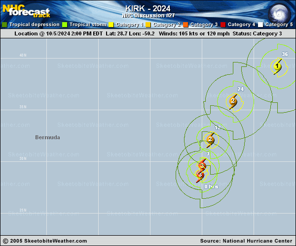
Copy of official data Hurricane Kirk Discussion Number 27 NWS National Hurricane Center Miami FL AL122024 1100 PM AST Sat Oct 05 2024 Kirk is gradually succumbing to the effects of increasing vertical wind shear. Based on geostationary satellite imagery, the eye is becoming more ragged and cloud-filled, and the southwestern quadrant is wrapping in more dry air. Dvorak estimates have decreased this cycle and the initial intensity is lowered to 100 kt, closest to the TAFB estimate of 102 kt. The hurricane is moving northward at 17 kt in the flow between a deep-layer trough over the western Atlantic and a subtropical ridge centered over the eastern Atlantic. Model guidance remains tightly clustered, and very few changes have been made to the latest official track forecast which lie close to the various consensus aids. Kirk is expected to move north of the Azores on Monday and move over western Europe Tuesday evening or Wednesday. Atmospheric and oceanic conditions are expected to become less conducive in the coming days. Vertical wind shear should become quite strong later Sunday, and Kirk is expected to cross the 26 degree C isotherm Sunday evening. Global models predict Kirk to become an extratropical cyclone on Tuesday and to then be absorbed into a larger extratropical system later this week over northern Europe. The latest NHC intensity forecast now reflects these changes. Kirk is producing ocean swells that are propagating far away from the hurricane. These large swells have increased the risk of dangerous surf and rip currents across the Leeward Islands, Bermuda, and the Greater Antilles, the Bahamas, and portions of the U.S. East Coast. By Sunday, swells are expected to spread northward along the eastern seaboard and reach the Azores by Monday. For more information on this hazard, see products issued by your local weather office. FORECAST POSITIONS AND MAX WINDS INIT 06/0300Z 31.3N 49.3W 100 KT 115 MPH 12H 06/1200Z 34.0N 48.1W 95 KT 110 MPH 24H 07/0000Z 37.6N 44.7W 85 KT 100 MPH 36H 07/1200Z 40.7N 39.7W 75 KT 85 MPH 48H 08/0000Z 42.8N 33.0W 65 KT 75 MPH...POST-TROP/EXTRATROP 60H 08/1200Z 43.7N 24.7W 55 KT 65 MPH...POST-TROP/EXTRATROP 72H 09/0000Z 44.1N 15.1W 50 KT 60 MPH...POST-TROP/EXTRATROP 96H 10/0000Z 49.5N 3.7E 40 KT 45 MPH...POST-TROP/EXTRATROP 120H 11/0000Z...DISSIPATED $$ Forecaster Bucci |