Official Discussion issued by the National Hurricane Center
Kirk (AL122024) DATA RELEASED: 10/5/2024 9:00:00 PM UTC
|
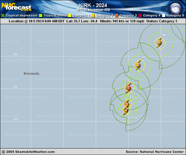
Copy of official data Hurricane Kirk Discussion Number 26 NWS National Hurricane Center Miami FL AL122024 500 PM AST Sat Oct 05 2024 Kirk continues to have a tight inner core, with deep convection wrapping around the center. The eye has continued to become more cloud filled, as shear increases over the system. The latest subjective and objective satellite intensity estimates have held mostly steady with this cycle, and the initial intensity is held at 105 kt. Kirk continues to move northward and increase forward speed with an estimated motion of (005/17 kt) between a trough located over the west-central Atlantic and a subtropical ridge in the east Atlantic. Model track guidance remains tightly clustered, although there has been a slight shift southward as the system transitions and becomes post-tropical. The NHC forecast track shows the center of Kirk passing just to the north of the Azores on Monday as an extratropical cyclone, and then moving across the northeastern Atlantic and over western Europe by the middle of next week. The official NHC track forecast is very similar to the previous advisory, with a slight nudge southward towards the end of the period following the consensus model trends. Wind shear has started to increase over Kirk this afternoon, but the inner core has been able to remain intact. However, the environment will only continue to become more hostile as wind shear continues to increase, with drier mid-level air, and cooler sea surface temperatures. Therefore, steady weakening is forecast through early next week. The system should lose tropical characteristics and transition to a strong extratropical cyclone around 60 h. The updated NHC intensity forecast is near the previous one in the near term, with a slightly faster rate of weakening in agreement with the latest HCCA and simple consensus aids. Kirk is producing ocean swells that are propagating far away from the hurricane. These large swells will likely increase the risk of dangerous surf and rip currents across the Leeward Islands, Bermuda, and the Greater Antilles beginning later today, much of the U.S. East Coast, Atlantic Canada, and the Bahamas by Sunday, and the Azores by Monday. For more information on this hazard, see products issued by your local weather office. FORECAST POSITIONS AND MAX WINDS INIT 05/2100Z 29.6N 50.0W 105 KT 120 MPH 12H 06/0600Z 32.1N 49.2W 95 KT 110 MPH 24H 06/1800Z 35.8N 47.0W 85 KT 100 MPH 36H 07/0600Z 39.2N 42.7W 75 KT 85 MPH 48H 07/1800Z 42.0N 36.9W 70 KT 80 MPH 60H 08/0600Z 43.5N 29.5W 60 KT 70 MPH...POST-TROP/EXTRATROP 72H 08/1800Z 44.3N 19.6W 50 KT 60 MPH...POST-TROP/EXTRATROP 96H 09/1800Z 47.7N .5W 45 KT 50 MPH...POST-TROP/EXTRATROP 120H 10/1800Z 55.8N 14.9E 30 KT 35 MPH...POST-TROP/EXTRATROP $$ Forecaster Kelly |