Official Discussion issued by the National Hurricane Center
Ernesto (AL052024) DATA RELEASED: 8/18/2024 3:00:00 AM UTC
|
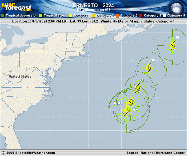
Copy of official data Tropical Storm Ernesto Discussion Number 26 NWS National Hurricane Center Miami FL AL052024 1100 PM AST Sat Aug 17 2024 Satellite imagery and radar data from Bermuda continue to show limited convection associated with Ernesto, with the strongest convection in a poorly-defined eyewall in the northern semicircle. This is likely due to a tongue of dry air wrapping around the system from the northwest into the central core. The various subjective and objective satellite intensity estimates have decreased a little more since the last advisory, and based on this the initial intensity is lowered to 60 kt. The initial motion is 030/7 kt. This slow motion should continue for the next 6-12 h as a mid-latitude shortwave ridge passes to the north of Ernesto. After that, southwesterly flow on the east side of a mid-latitude trough moving through the eastern United States should cause the cyclone to accelerate to the north-northeast, northeast, and eventually east-northeast. This motion should bring the center just southeast of Newfoundland late Monday and Monday night, with the system moving into the open north Atlantic thereafter. The track guidance remains tightly clustered, and the new forecast track has only minor changes from the previous track. Little change in strength is expected tonight while Ernesto tries to mix out the dry air tongue. After that, upper-level divergence is forecast to increase while the cyclone is still over relatively warm water. This could allow some modest re-intensification as show by the dynamical models, and this remains reflected in the intensity forecast. After 36 h, the cyclone should weaken as it moves over colder water and begins extratropical transition. Transition should be complete by 60 h, and and the post-tropical low is expected to degenerate to a trough over the northeastern Atlantic between 72-96 h. Key Messages: 1. Ernesto is still moving slowly, and its impacts on Bermuda are not quite over. Strong winds, heavy rainfall, coastal flooding, and battering waves should continue for a few more hours. The heavy rains will likely result in considerable life-threatening flash flooding, especially in low-lying areas on the island. 2. Even though Ernesto is forecast to remain well offshore the U.S. East Coast, swells generated by the hurricane are expected to affect the area through early next week. Beach goers should be aware that there is a significant risk of life-threatening surf and rip currents, and should stay out of the water if advised by lifeguards. Surf and rip currents are also possible on the Bahamas, Bermuda, and Atlantic Canada during the next few days. 3. Ernesto could bring wind, wave, and rain impacts to portions of southeastern Newfoundland late Monday and Monday night. FORECAST POSITIONS AND MAX WINDS INIT 18/0300Z 33.9N 63.3W 60 KT 70 MPH 12H 18/1200Z 35.3N 62.9W 60 KT 70 MPH 24H 19/0000Z 37.9N 61.6W 65 KT 75 MPH 36H 19/1200Z 41.3N 58.8W 70 KT 80 MPH 48H 20/0000Z 44.7N 53.8W 65 KT 75 MPH 60H 20/1200Z 47.7N 46.2W 50 KT 60 MPH...POST-TROP/EXTRATROP 72H 21/0000Z 50.4N 36.9W 40 KT 45 MPH...POST-TROP/EXTRATROP 96H 22/0000Z...DISSIPATED $$ Forecaster Beven |