Official Discussion issued by the National Hurricane Center
Leslie (AL132024) DATA RELEASED: 10/8/2024 3:00:00 PM UTC
|
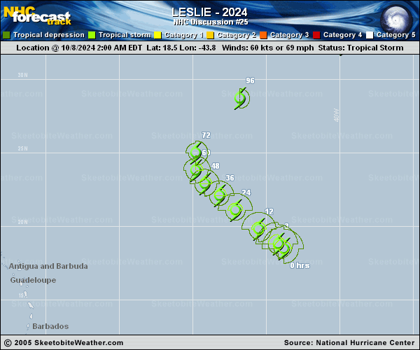
Copy of official data Tropical Storm Leslie Discussion Number 25 NWS National Hurricane Center Miami FL AL132024 1100 AM AST Tue Oct 08 2024 Satellite images show Leslie has made a bit of a comeback this morning, with convection trying to wrap around the center. Microwave passes also display that Leslie still has some inner-core features including a partial eyewall. Overall, Dvorak estimates are about the same as earlier, so the initial wind speed will stay 60 kt. Plentiful dry air in the mid-levels of the atmosphere has been preventing sustained deep convection near Leslie, despite low-to-moderate shear. Leslie does have a short window where the shear diminishes later today and tomorrow, though Leslie will also be contending with less instability near the wake of Kirk. While some of the guidance is showing re-strengthening, the above factors generally argue for little significant change during the next day or so. The new forecast is nudged higher than the previous one, but lies below the model consensus through 36 hours. After that time, the storm should encounter strong northerly flow of over 50 kt, which is forecast to cause Leslie to quickly decouple and degenerate into a remnant low by this weekend. The initial motion is estimated to be northwestward, or 310/11 kt. There are no significant track changes to report as Leslie is being steered around the southwest to northwest sides of the subtropical ridge, causing the storm's motion to change to the north late tomorrow and then recurve to the northeast later this week. Only cosmetic changes were made to the last NHC forecast. FORECAST POSITIONS AND MAX WINDS INIT 08/1500Z 19.4N 45.6W 60 KT 70 MPH 12H 09/0000Z 20.5N 46.7W 60 KT 70 MPH 24H 09/1200Z 21.7N 47.9W 60 KT 70 MPH 36H 10/0000Z 22.6N 48.7W 60 KT 70 MPH 48H 10/1200Z 23.4N 49.4W 55 KT 65 MPH 60H 11/0000Z 24.6N 49.8W 50 KT 60 MPH 72H 11/1200Z 26.3N 48.9W 40 KT 45 MPH...POST-TROPICAL 96H 12/1200Z 30.7N 43.7W 35 KT 40 MPH...POST-TROPICAL 120H 13/1200Z 34.0N 36.0W 30 KT 35 MPH...POST-TROP/REMNT LOW $$ Forecaster Blake |