Official Discussion issued by the National Hurricane Center
Kirk (AL122024) DATA RELEASED: 10/5/2024 3:00:00 PM UTC
|
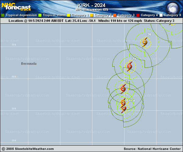
Copy of official data Hurricane Kirk Discussion Number 25 NWS National Hurricane Center Miami FL AL122024 1100 AM AST Sat Oct 05 2024 The inner core of Kirk has become a little less pronounced and ragged on satellite imagery, with the eye becoming more cloud filled. Shear is starting to increase over the system with some drier air intrusions becoming evident. The latest subjective and objective satellite intensity estimates have come down with this cycle, and the initial intensity is lowered to 105 kt. Kirk continues to turn more northward (355/14 kt) within the flow between a shortwave trough over the west-central Atlantic and a subtropical ridge to the east Atlantic Model guidance is in fairly good agreement that Kirk should keep turning to the northeast and east-northeast through early next week and increasing forward motion. The NHC forecast track shows the center of Kirk passing to the north of the Azores on Monday as an extratropical cyclone, and then moving across the northeastern Atlantic and over western Europe by the middle of next week. The official NHC track forecast is very similar to the previous advisory. The hurricane is getting ready to move into a hostile environment with increasing shear and drier air. The system will also be traversing cooler sea surface temperatures throughout the forecast period. Therefore, steady weakening is forecast through early next week. The system should lose tropical characteristics and transition to a strong extratropical cyclone around 60 h, which is supported by the global model fields and simulated satellite imagery. The updated NHC intensity forecast is near the previous in the near term, with a slightly faster rate of weakening beyond 60 h in agreement with the latest HCCA and simple consensus aids. Kirk is producing ocean swells that are propagating far away from the hurricane. These large swells will likely increase the risk of dangerous surf and rip currents across the Leeward Islands, Bermuda, and the Greater Antilles beginning later today, much of the U.S. East Coast, Atlantic Canada, and the Bahamas by Sunday, and the Azores by Monday. For more information on this hazard, see products issued by your local weather office. FORECAST POSITIONS AND MAX WINDS INIT 05/1500Z 27.6N 50.3W 105 KT 120 MPH 12H 06/0000Z 30.1N 50.0W 100 KT 115 MPH 24H 06/1200Z 33.6N 48.5W 90 KT 105 MPH 36H 07/0000Z 37.1N 45.3W 85 KT 100 MPH 48H 07/1200Z 40.4N 40.2W 75 KT 85 MPH 60H 08/0000Z 42.5N 33.5W 65 KT 75 MPH...POST-TROP/EXTRATROP 72H 08/1200Z 43.5N 24.5W 55 KT 65 MPH...POST-TROP/EXTRATROP 96H 09/1200Z 47.2N 5.2W 50 KT 60 MPH...POST-TROP/EXTRATROP 120H 10/1200Z 54.9N 8.2E 40 KT 45 MPH...POST-TROP/EXTRATROP $$ Forecaster Kelly |