Official Discussion issued by the National Hurricane Center
Ernesto (AL052024) DATA RELEASED: 8/17/2024 3:00:00 PM UTC
|
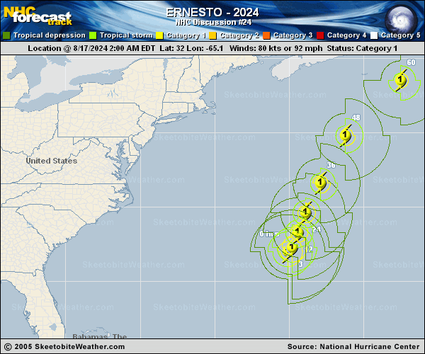
Copy of official data Hurricane Ernesto Discussion Number 24 NWS National Hurricane Center Miami FL AL052024 1100 AM AST Sat Aug 17 2024 An Air Force Reserve Hurricane Hunter aircraft made a couple of passes through Ernesto this morning and only found 700-mb flight level winds as high as 74 kt--significantly lower than the maximum winds reported by the mission yesterday evening and overnight. The initial intensity is therefore set at 70 kt for this advisory, and even that could be a bit generous. Although the central pressure has not risen much, Ernesto's wind field has continued to expand, and the hurricane is now exhibiting a large rain-free center region that is just about to move past Bermuda. The forward motion has slowed a bit more and is now estimated to be north-northeastward (025 degrees) at 7 kt. Ernesto has been left behind by a shortwave trough now located near Newfoundland, and therefore a continued slow motion toward the north-northeast is forecast for the next day or so until another trough to the west gets closer. Ernesto should begin accelerating on Sunday as it heads toward Atlantic Canada, turning northeastward and passing very near southeastern Newfoundland late Monday and Monday night. The guidance has again slowed down on this cycle, and the NHC forecast has been adjusted accordingly. Although deep-layer shear is forecast to diminish a bit during the next 24 hours while Ernesto remains over waters of 28 degrees Celsius, the structure of the hurricane and dry air within the circulation suggest that the storm may not be able to re-intensity much, if at all. The NHC intensity forecast is near the top end of the guidance and does keep Ernesto as a hurricane for the next 48 hours. Weakening is expected after that time, and global model fields suggest Ernesto should become extratropical by 72 hours while or just after passing Newfoundland. A 96-hour point is provided for continuity, but both the GFS and ECMWF indicate that the circulation could open up into a trough over the north Atlantic by then. Key Messages: 1. Ernesto is moving slowly, and its impacts on Bermuda are not over. Strong winds, heavy rainfall, coastal flooding, and battering waves are likely through tonight. The heavy rains will likely result in considerable life-threatening flash flooding, especially in low-lying areas on the island. 2. Even though Ernesto is forecast to remain well offshore the U.S. East Coast, swells generated by the hurricane are expected to affect the area through early next week. Beach goers should be aware that there is a significant risk of life-threatening surf and rip currents, and should stay out of the water if advised by lifeguards. Surf and rip currents are also possible on the Bahamas, Bermuda, and Atlantic Canada during the next few days. 3. Ernesto could bring wind, wave, and rain impacts to portions of southeastern Newfoundland late Monday and Monday night. FORECAST POSITIONS AND MAX WINDS INIT 17/1500Z 32.9N 64.4W 70 KT 80 MPH 12H 18/0000Z 33.7N 63.9W 65 KT 75 MPH 24H 18/1200Z 35.3N 63.3W 65 KT 75 MPH 36H 19/0000Z 37.9N 62.0W 65 KT 75 MPH 48H 19/1200Z 41.3N 59.5W 70 KT 80 MPH 60H 20/0000Z 44.9N 54.7W 60 KT 70 MPH 72H 20/1200Z 47.7N 47.2W 50 KT 60 MPH...POST-TROP/EXTRATROP 96H 21/1200Z 51.2N 27.8W 35 KT 40 MPH...POST-TROP/EXTRATROP 120H 22/1200Z...DISSIPATED $$ Forecaster Berg |