Official Discussion issued by the National Hurricane Center
(AL142024) DATA RELEASED: 10/10/2024 9:00:00 PM UTC
|
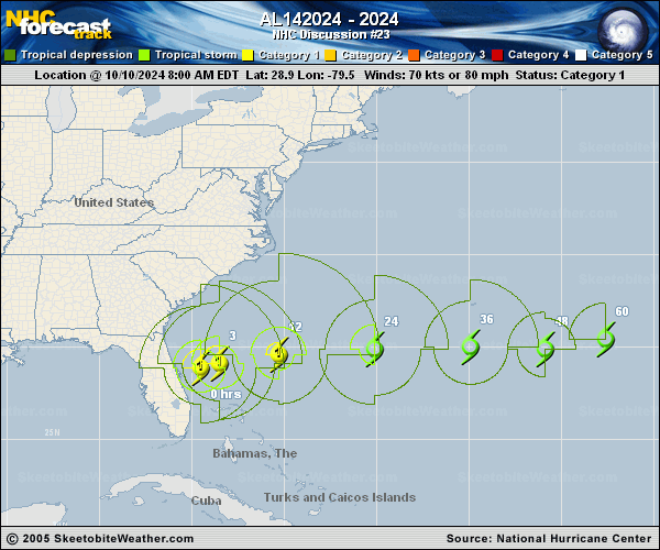
Copy of official data Post-Tropical Cyclone Milton Discussion Number 23 NWS National Hurricane Center Miami FL AL142024 500 PM EDT Thu Oct 10 2024 Milton's satellite appearance has continued to take on an extratropical appearance, and ASCAT data from a few hours ago confirmed that the cyclone has become frontal. Based on that information, Milton was declared post tropical in the 2 pm intermediate advisory. The ASCAT passes showed maximum winds of 55-60 kt to the northwest of the center, so the initial intensity is set to 60 kt. Milton has turned eastward and sped up a bit (080/18 kt). A general eastward motion with an increase in forward speed is expected during the next several days, with the extratropical low forecast to pass south of Bermuda in 24-36 hours. Global model fields and intensity models indicate that the intensity should gradually decrease during the next several days, and this is reflected in the official forecast. Dissipation is shown by day 4, although there is still some uncertainty if Milton will become absorbed by the frontal zone before that time, or retain its identity beyond 4 days. Since all storm surge and tropical storm warnings have been discontinued, this will be the last advisory on Milton. Additional information on this system can be found in High Seas Forecasts issued by the National Weather Service, under AWIPS header NFDHSFAT1, WMO header FZNT01 KWBC, and online at ocean.weather.gov/shtml/NFDHSFAT1.php Key Messages: 1. Gusty winds and coastal flooding will gradually diminish along portions of the southeastern U.S. coast through tonight. 2. In the wake of heavy rainfall from Milton, the risk of considerable urban flooding will linger through this evening across east central Florida. Moderate to major river flooding is ongoing and forecast throughout central Florida. 3. In Florida, continue to use caution since deadly hazards remain, including downed power lines and flooded areas. Ensure generators are properly ventilated and placed outside at least 20 feet away from doors, windows, and garages to avoid carbon monoxide poisoning. If you are cleaning up storm damage, be careful when using chainsaws and power tools, and drink plenty of water to avoid heat exhaustion. FORECAST POSITIONS AND MAX WINDS INIT 10/2100Z 29.5N 76.3W 60 KT 70 MPH...POST-TROP/EXTRATROP 12H 11/0600Z 29.6N 72.8W 60 KT 70 MPH...POST-TROP/EXTRATROP 24H 11/1800Z 29.8N 67.4W 50 KT 60 MPH...POST-TROP/EXTRATROP 36H 12/0600Z 30.4N 62.3W 40 KT 45 MPH...POST-TROP/EXTRATROP 48H 12/1800Z 31.0N 58.5W 35 KT 40 MPH...POST-TROP/EXTRATROP 60H 13/0600Z 32.1N 54.6W 30 KT 35 MPH...POST-TROP/EXTRATROP 72H 13/1800Z 33.7N 49.6W 25 KT 30 MPH...POST-TROP/EXTRATROP 96H 14/1800Z...DISSIPATED $$ Forecaster Berg |