Official Discussion issued by the National Hurricane Center
Milton (AL142024) DATA RELEASED: 10/10/2024 3:00:00 PM UTC
|
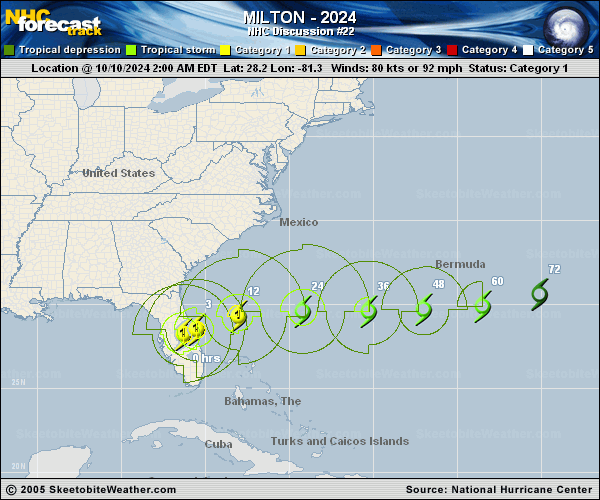
Copy of official data Hurricane Milton Discussion Number 22 NWS National Hurricane Center Miami FL AL142024 1100 AM EDT Thu Oct 10 2024 Milton is quickly taking on extratropical characteristics, with convection more closely aligned along a warm frontal boundary to the northeast than the center itself. Due to the structure evolution, it is likely that the strongest winds are located to the northwest of the center. The intensity is lowered to 70 kt, based on continuity from the previous forecast. Scatterometer passes are expected in a few hours and should allow us to get a better handle on Milton's intensity and structure. The hurricane has turned east-northeastward (065/17 kt). Milton is located within the base of a deep-layer trough located over the western Atlantic, and this feature should steer the storm eastward later today, with that motion continuing for the next 3 days. The NHC forecast is a little faster than the previous prediction to follow the recent trends in the model guidance. Global model fields show low-level thickness contours packing closer together on the northwest side through the day, and it is therefore likely that Milton will complete extratropical transition by this afternoon or evening. Milton will still be a powerful post-tropical cyclone, but its maximum winds are expected to gradually decrease during the next few days. The post-tropical low is expected to become diffuse and will likely dissipate in about 4 days. Key Messages: 1. A Storm Surge Warning remains in effect for portions of the east coast of Florida and southern coast of Georgia. Storm surge inundation will continue in these areas through this afternoon. 2. Tropical storm conditions will continue along portions of the southeast U.S. coast through this afternoon and over the extreme northwestern Bahamas through this evening. 3. In the wake of heavy rainfall from Milton, the risk of considerable urban flooding will linger through this afternoon across east central Florida. Moderate to major river flooding is ongoing and forecast throughout central Florida. 4. Use caution after the storm as deadly hazards remain including downed power lines and flooded areas. Ensure generators are properly ventilated and placed outside at least 20 feet away from doors, windows, and garages to avoid carbon monoxide poisoning. If you are cleaning up storm damage, be careful when using chainsaws and power tools, and drink plenty of water to avoid heat exhaustion. FORECAST POSITIONS AND MAX WINDS INIT 10/1500Z 29.1N 78.5W 70 KT 80 MPH 12H 11/0000Z 29.6N 75.3W 65 KT 75 MPH...POST-TROP/EXTRATROP 24H 11/1200Z 29.9N 70.1W 55 KT 65 MPH...POST-TROP/EXTRATROP 36H 12/0000Z 30.0N 64.9W 45 KT 50 MPH...POST-TROP/EXTRATROP 48H 12/1200Z 29.9N 60.9W 40 KT 45 MPH...POST-TROP/EXTRATROP 60H 13/0000Z 30.4N 57.6W 35 KT 40 MPH...POST-TROP/EXTRATROP 72H 13/1200Z 31.4N 53.9W 30 KT 35 MPH...POST-TROP/EXTRATROP 96H 14/1200Z...DISSIPATED $$ Forecaster Berg |