Official Discussion issued by the National Hurricane Center
Kirk (AL122024) DATA RELEASED: 10/4/2024 9:00:00 PM UTC
|
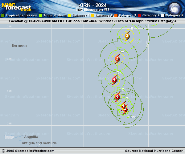
Copy of official data Hurricane Kirk Discussion Number 22 NWS National Hurricane Center Miami FL AL122024 500 PM AST Fri Oct 04 2024 Kirk has changed little in structure during the past several hours and remains an impressive hurricane with a well-defined eye inside a central dense overcast. There has been no recent microwave imagery to determine if the apparent outer eyewall seen earlier is still there. The various subjective and objective satellite intensity estimates are mostly near 115 kt, so the initial intensity for this advisory is set at that. The initial motion is now 325/10. Kirk is currently approaching a large break in the subtropical ridge caused by a deep-layer low centered near 33N 61W. During the next 48 h, the hurricane should recurve through this break and accelerate northeastward into the mid-latitude westerlies. After that time, the cyclone should move quickly east-northeastward across the northern and northeastern Atlantic. The track guidance more or less is the same as seen in the previous advisory, with the exception of a southward nudge near 96 h. The new forecast track also has this nudge, but is otherwise little changed from the previous track. Fluctuations in intensity are likely during the next 12 h due to the possible eyewall replacement cycle. After that, Kirk should encounter increasing southwesterly shear and move over cooler sea surface temperatures, which should cause a steady weakening. Extratropical transition is likely to begin between 60-72 h and be complete by 96 h, with Kirk becoming a strong extratropical cyclone over the northeastern Atlantic. The new intensity forecast again follows the general trends of the intensity guidance, and is closest to the GFS model forecast during the extratropical stage. Even though Kirk is expected to recurve over the open Atlantic, its strong intensity and increasing size will result in large ocean swells that will propagate far away from the hurricane. These swells will likely increase the risk of dangerous surf and rip currents across the Leeward Islands beginning this evening, Bermuda and the Greater Antilles by Saturday, much of the U.S. East Coast, Atlantic Canada, and the Bahamas by Sunday, and the Azores by Monday. For more information on this hazard, see products issued by your local weather office. FORECAST POSITIONS AND MAX WINDS INIT 04/2100Z 23.7N 49.4W 115 KT 130 MPH 12H 05/0600Z 25.5N 50.0W 115 KT 130 MPH 24H 05/1800Z 28.5N 50.1W 110 KT 125 MPH 36H 06/0600Z 32.0N 49.1W 100 KT 115 MPH 48H 06/1800Z 35.6N 46.5W 90 KT 105 MPH 60H 07/0600Z 39.1N 42.0W 80 KT 90 MPH 72H 07/1800Z 42.0N 36.0W 70 KT 80 MPH 96H 08/1800Z 45.0N 19.0W 50 KT 60 MPH...POST-TROP/EXTRATROP 120H 09/1800Z 49.5N 3.0W 45 KT 50 MPH...POST-TROP/EXTRATROP $$ Forecaster Beven |