Official Discussion issued by the National Hurricane Center
Ernesto (AL052024) DATA RELEASED: 8/17/2024 3:00:00 AM UTC
|
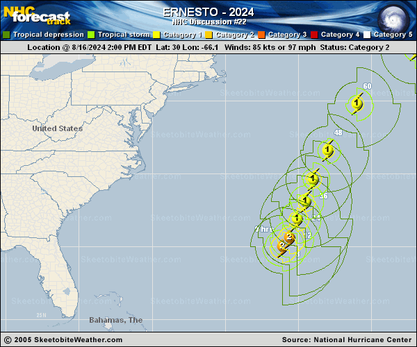
Copy of official data Hurricane Ernesto Discussion Number 22 NWS National Hurricane Center Miami FL AL052024 1100 PM AST Fri Aug 16 2024 Ernesto is very near Bermuda. The island has been in the northern rainbands since this afternoon, and the eyewall is closing in on the island as seen in Bermuda's Doppler radar images. So far, tropical-storm-force winds with gusts to hurricane force have been observed on Bermuda, and the strongest winds will likely occur there during the next several hours. The Air Force Hurricane Hunters have been investigating Ernesto this evening and found that the minimum pressure has been steady around 969 mb. A blend of the latest flight-level and SFMR winds support an initial intensity of about 80 kt. Recent microwave images indicate that the vortex is tilted to the east-northeast with height due to about 20 kt of west-southwesterly vertical wind shear. The already tilted vortex coupled with continued moderate to strong shear and possible intrusions of dry air should cause some weakening during the next day or so. However, the shear is expected to lessen during the 24- to 60-h time period, and since Ernesto will still be over the Gulf Stream Current then, the weakening trend should pause. In fact, Ernesto is forecast to strengthen some during that time, following the hurricane regional models and consensus aids. On Monday, the cyclone is predicted to cross the north wall of the Gulf Stream and track over sharply cooler waters while moving into a strong wind shear environment. Therefore, steady weakening is forecast at that point, and Ernesto is expected to complete extratropical transition shortly after day 3. The NHC intensity forecast is largely an update of the previous one. Ernesto is still moving northeastward at 11 kt, however, the hurricane is expected to slow down soon as the trough off Atlantic Canada continues to lift out. The expected slower motion and Ernesto's large size will cause a long duration of impacts through Saturday night on Bermuda. After the hurricane pulls away from Bermuda, another trough is forecast to push off the U.S. east coast. This feature should cause the cyclone to accelerate northeastward later in the weekend and early next week, taking Ernesto near Newfoundland Monday night. The NHC track forecast is a little slower than the previous one to come into better agreement with the latest models. Key Messages: 1. Ernesto is expected to bring a prolonged period of strong winds and storm surge on Bermuda through Saturday night. A hurricane warning is in effect for the island. Residents there should listen to orders from local officials. 2. Heavy rainfall associated with Ernesto is expected to impact Bermuda through Saturday and will likely result in considerable life-threatening flash flooding, especially in low-lying areas on the island. 3. Even though Ernesto is forecast to remain well offshore the U.S. East Coast, swells generated by the hurricane are expected to affect the area through the weekend. Beach goers should be aware of a significant risk of life-threatening surf and rip currents, and stay out of the water if advised by lifeguards. Surf and rip currents are also possible on the Bahamas, Bermuda, and Atlantic Canada during the next few days. FORECAST POSITIONS AND MAX WINDS INIT 17/0300Z 31.4N 65.2W 80 KT 90 MPH 12H 17/1200Z 32.6N 64.6W 75 KT 85 MPH 24H 18/0000Z 33.7N 64.1W 70 KT 80 MPH 36H 18/1200Z 35.3N 63.4W 75 KT 85 MPH 48H 19/0000Z 38.1N 61.9W 80 KT 90 MPH 60H 19/1200Z 41.5N 59.1W 80 KT 90 MPH 72H 20/0000Z 45.1N 54.1W 65 KT 75 MPH 96H 21/0000Z 51.3N 36.9W 45 KT 50 MPH...POST-TROP/EXTRATROP 120H 22/0000Z 54.7N 17.4W 35 KT 40 MPH...POST-TROP/EXTRATROP $$ Forecaster Cangialosi |