Official Discussion issued by the National Hurricane Center
Leslie (AL132024) DATA RELEASED: 10/7/2024 3:00:00 PM UTC
|
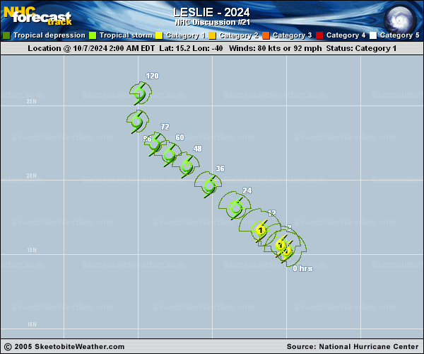
Copy of official data Hurricane Leslie Discussion Number 21 NWS National Hurricane Center Miami FL AL132024 1100 AM AST Mon Oct 07 2024 Leslie appears slightly less organized based on infrared and visible satellite imagery. However, an SSMIS microwave pass from a few hours ago indicated that there was still a feature resembling an eye on the 91-GHz imagery. Subjective Dvorak estimates from TAFB and SAB are T-4.5/77 kt. The objective estimates from UW-CIMSS range from 65 to 84 kt. The initial intensity is nudged down slightly to 75 kt, based on the degraded satellite presentation noted on conventional satellite imagery. Leslie is moving northwestward, or 315/11 kt. Leslie is expected to move around the southwestern periphery of a subtropical ridge to the northeast of the cyclone and turn gradually north-northwestward to northward toward the end of the week. The NHC track forecast was nudged only slightly to the right of the previous official forecast during the first 72 h of the forecast and is close to the various track consensus aids. Leslie will remain over warm ocean water through the 5-day forecast period, and it will remain in an environment of relatively low vertical wind shear for another 48 h. However, dry air in the lower and middle troposphere should prevent any strengthening. In fact, the bulk of the intensity guidance shows weakening, and the NHC forecast follows suit. Due to Leslie's small size, its core seems to be vulnerable to the dry air, despite the low shear. Only minor changes are made to the official intensity forecast, which lies near the lower end of the intensity guidance. Beyond 48 h, Leslie is forecast to run into strong northerly wind shear as the cyclone interacts with an upper-level trough. This shear will cause continued weakening. Simulated satellite imagery is showing Leslie losing its convection beyond day 4, and the NHC forecast shows the tropical cyclone becoming post-tropical in 4 to 5 days. FORECAST POSITIONS AND MAX WINDS INIT 07/1500Z 16.4N 41.2W 75 KT 85 MPH 12H 08/0000Z 17.5N 42.5W 65 KT 75 MPH 24H 08/1200Z 19.0N 44.2W 60 KT 70 MPH 36H 09/0000Z 20.5N 45.9W 55 KT 65 MPH 48H 09/1200Z 21.6N 47.2W 55 KT 65 MPH 60H 10/0000Z 22.4N 48.3W 50 KT 60 MPH 72H 10/1200Z 23.1N 49.1W 45 KT 50 MPH 96H 11/1200Z 24.7N 50.0W 40 KT 45 MPH 120H 12/1200Z 27.0N 48.9W 35 KT 40 MPH...POST-TROPICAL $$ Forecaster Hagen |