Official Discussion issued by the National Hurricane Center
Kirk (AL122024) DATA RELEASED: 10/4/2024 3:00:00 PM UTC
|
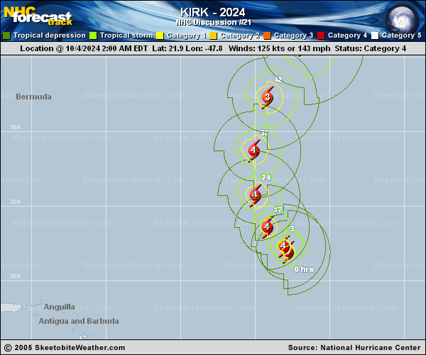
Copy of official data Hurricane Kirk Discussion Number 21 NWS National Hurricane Center Miami FL AL122024 1100 AM AST Fri Oct 04 2024 The satellite appearance of Kirk is a little less impressive than it was six hours ago, as the eye has become somewhat cloud-filled and the convective cloud tops have warmed a little. Recent microwave imagery suggests that the hurricane may be starting an eyewall replacement cycle, with an outer convective band wrapped about three-quarters of the way around the eyewall. The various objective and subjective satellite intensity estimates have trended downward, and based on a combination of these estimates the initial intensity is reduced to 120 kt. The wind radii have been tweaked based on a recent ASCAT overpass. The initial motion is 315/10. Kirk is currently approaching a large break in the subtropical ridge caused by a deep-layer low centered near 33N 60W. During the next 48-60 h, the hurricane should recurve through this break and accelerate northeastward into the mid-latitude westerlies. After that time, the cyclone should move quickly east-northeastward across the northern and northeastern Atlantic. There has been little change in the track guidance since the previous advisory, and the new forecast track has only minor adjustments from the previous track. Fluctuations in intensity are likely during the next 24 h due to the expected eyewall replacement cycle. After that, Kirk should encounter increasing southwesterly shear and move over cooler sea surface temperatures, which should cause a steady weakening. Extratropical transition is likely to begin between 60-72 h and be complete by 96 h, with Kirk becoming a strong extratropical cyclone over the northeastern Atlantic. The new intensity forecast follows the general trends of the intensity guidance, and is closest to the GFS model during the extratropical stage. Even though Kirk is expected to recurve over the open Atlantic, its strong intensity and increasing size will result in large ocean swells that will propagate far away from the hurricane. These swells will likely increase the risk of dangerous surf and rip currents across the Leeward Islands beginning later today, Bermuda and the Greater Antilles by Saturday, much of the U.S. East Coast, Atlantic Canada, and the Bahamas by Sunday, and the Azores by Monday. For more information on this hazard, see products issued by your local weather office. FORECAST POSITIONS AND MAX WINDS INIT 04/1500Z 23.0N 48.9W 120 KT 140 MPH 12H 05/0000Z 24.4N 49.8W 115 KT 130 MPH 24H 05/1200Z 27.0N 50.3W 115 KT 130 MPH 36H 06/0000Z 30.3N 49.8W 110 KT 125 MPH 48H 06/1200Z 33.8N 48.3W 95 KT 110 MPH 60H 07/0000Z 37.6N 44.6W 85 KT 100 MPH 72H 07/1200Z 40.9N 39.3W 75 KT 85 MPH 96H 08/1200Z 45.3N 25.4W 55 KT 65 MPH...POST-TROP/EXTRATROP 120H 09/1200Z 48.0N 9.0W 50 KT 60 MPH...POST-TROP/EXTRATROP $$ Forecaster Beven |