Official Discussion issued by the National Hurricane Center
Ernesto (AL052024) DATA RELEASED: 8/16/2024 9:00:00 PM UTC
|
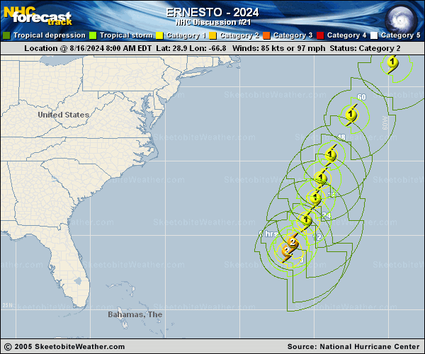
Copy of official data Hurricane Ernesto Discussion Number 21 NWS National Hurricane Center Miami FL AL052024 500 PM AST Fri Aug 16 2024 After looking quite ragged this morning, Ernesto's structure on satellite has made a comeback. A burst of convection that began after the last advisory has wrapped around the western side of the hurricane, and the eye has also tried to clear. The structural improvement in Ernesto was also seen from the last couple of Air Force and NOAA Hurricane Hunter fixes which indicated the eyewall definition had improved while remaining quite large. This improved eyewall can also be seen on radar imagery out of Bermuda. Before departing, the peak flight-level winds from the NOAA-P3 aircraft was 107 kt at 750 mb, while the Air Force reconnaissance measured 99 kt at 700 mb. While the satellite-based intensity estimates are a bit lower, the initial intensity will be held at 85 kt given the higher aircraft observations and improvement in structure this afternoon. Of note, Saildrone SD-1068 appears to currently be in the northwest eyewall of Ernesto and recently reported wind gusts of hurricane-force and significant wave heights up to 36 feet. Ernesto has maintained a north-northeast track this afternoon, estimated at 035/11 kt. There isn't much change in the track thinking this afternoon, as a mid to upper-level trough that has been helping the hurricane move poleward will leave Ernesto behind over the next day or two. While Ernesto will remain steered by a subtropical ridge to its southeast, it is still forecast to temporarily slow its north-northeastward motion. Thereafter, another shortwave trough moving into the Great Lakes region is expected to dig southeastward over the Eastern U.S. and act as a kicker that will help to accelerate Ernesto more northeastward between forecast days 2 to 3. There is not much change to the track guidance this afternoon, just perhaps a touch slower after the next 24 hours, and the NHC track forecast lies very close to the prior one, close to the multi-model consensus aids. Based on the latest track, Ernesto's large eye will likely be very near or over Bermuda tomorrow morning. Intensity-wise, the model guidance continues to be insistent that Ernesto will weaken some in the short term as it battles 20-25 kt vertical wind shear out of the west, though so far Ernesto has been been more resilient than expected, possibly due to its large size. Nonetheless, this NHC intensity forecast will show some weakening, though not as much as IVCN or some of the hurricane-regional models over the next 24 h. After that time, shear decreases again while Ernesto will remain over 27-28 C sea-surface temperatures, and the intensity guidance responds to these more favorable conditions by showing some restrengthening. Finally, after 60 h, Ernesto will quickly cross the north wall of the Gulf Stream as the shear also begins to rapidly increase again. The NHC intensity forecast shows the hurricane completing extratropical tradition just after 72 h as the system passes nearby the southeastern coast of Newfoundland Canada. Key Messages: 1. Ernesto is expected to bring a prolonged period of strong winds and storm surge on Bermuda that is beginning currently and expected to continue through Saturday night. A hurricane warning is in effect for the island, and preparations to protect life and property should be completed as tropical-storm-force winds are already being observed on the island. 2. Heavy rainfall associated with Ernesto is expected to impact Bermuda through Saturday and will likely result in considerable life-threatening flash flooding, especially in low-lying areas on the island. 3. Even though Ernesto is forecast to remain well offshore the U.S. East Coast, swells generated by the hurricane are expected to affect the area through the weekend. Beach goers should be aware of a significant risk of life-threatening surf and rip currents, and stay out of the water if advised by lifeguards. Surf and rip currents are also possible on the Turks and Caicos, the Bahamas, Bermuda, and Atlantic Canada during the next few days. FORECAST POSITIONS AND MAX WINDS INIT 16/2100Z 30.6N 65.6W 85 KT 100 MPH 12H 17/0600Z 31.9N 65.1W 80 KT 90 MPH 24H 17/1800Z 33.1N 64.5W 75 KT 85 MPH 36H 18/0600Z 34.6N 64.0W 70 KT 80 MPH 48H 18/1800Z 36.6N 63.0W 75 KT 85 MPH 60H 19/0600Z 39.8N 61.0W 80 KT 90 MPH 72H 19/1800Z 43.5N 57.0W 70 KT 80 MPH 96H 20/1800Z 50.0N 42.5W 50 KT 60 MPH...POST-TROP/EXTRATROP 120H 21/1800Z 53.5N 22.4W 35 KT 40 MPH...POST-TROP/EXTRATROP $$ Forecaster Papin |