Official Discussion issued by the National Hurricane Center
Kirk (AL122024) DATA RELEASED: 10/4/2024 9:00:00 AM UTC
|
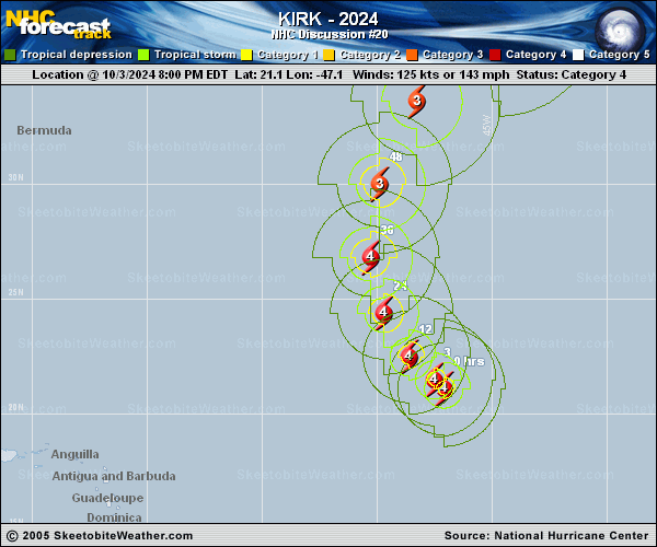
Copy of official data Hurricane Kirk Discussion Number 20 NWS National Hurricane Center Miami FL AL122024 500 AM AST Fri Oct 04 2024 Kirk remains a large, powerful hurricane with an impressive satellite presentation. The hurricane has a clear, circular 20 n mi- wide eye that is surrounded by a ring of very deep convection. The latest subjective Dvorak data-T numbers from TAFB and SAB are T6.0/115 kt, while the various UW-CIMSS objective estimates are around 125-130 kt. A blend of these values supports holding the initial intensity at 125 kt. The wind radii of Kirk were made slightly larger based on an earlier ASCAT overpass. A subtropical high to the northeast of Kirk is steering the hurricane northwestward (310/9 kt), but a northward turn is expected on Saturday while the hurricane moves between the western extent of the subtropical ridge and a shortwave trough approaching from the west. Then, Kirk is forecast to accelerate northeastward into the mid-latitudes on Sunday through early next week, ahead of a deep-layer trough moving across the northern Atlantic. The track guidance agrees on this recurvature scenario, and the NHC prediction is very similar to the previous one with only slight left-of-track adjustments to follow the multi-model consensus trends. Satellite intensity estimates peaked overnight, and there is evidence of some restriction of Kirk's upper-level outflow to the west of the hurricane in recent satellite images. The shear is expected to increase over Kirk during the next few days, along with the potential for intrusions of dry air that could disrupt the hurricane's convective organization. So while small short-term intensity fluctuations are possible, the overall forecast trend is for gradual weakening through Saturday, with more steady weakening into early next week. As Kirk moves over cooler waters and into a more baroclinic environment, it is expected to lose tropical characteristics and transition to a strong extratropical cyclone by 96 h over the northeastern Atlantic. The NHC intensity forecast closely follows the latest HCCA aid. Even though Kirk is expected to recurve over the open Atlantic, its strong intensity and increasing size will result in large ocean swells that will propagate far away from the hurricane. These swells will likely increase the risk of dangerous surf and rip currents across the Leeward Islands beginning later today, Bermuda and the Greater Antilles by Saturday, much of the U.S. East Coast, Atlantic Canada, and the Bahamas by Sunday, and the Azores by Monday. For more information on this hazard, see products issued by your local weather office. FORECAST POSITIONS AND MAX WINDS INIT 04/0900Z 22.3N 48.1W 125 KT 145 MPH 12H 04/1800Z 23.6N 49.2W 125 KT 145 MPH 24H 05/0600Z 25.7N 50.0W 125 KT 145 MPH 36H 05/1800Z 28.7N 50.1W 120 KT 140 MPH 48H 06/0600Z 32.3N 49.2W 105 KT 120 MPH 60H 06/1800Z 35.8N 46.7W 95 KT 110 MPH 72H 07/0600Z 39.8N 42.0W 85 KT 100 MPH 96H 08/0600Z 45.0N 29.0W 65 KT 75 MPH...POST-TROP/EXTRATROP 120H 09/0600Z 47.0N 14.5W 55 KT 65 MPH...POST-TROP/EXTRATROP $$ Forecaster Reinhart |