Official Discussion issued by the National Hurricane Center
Joyce (AL112024) DATA RELEASED: 9/27/2024 9:00:00 PM UTC
|
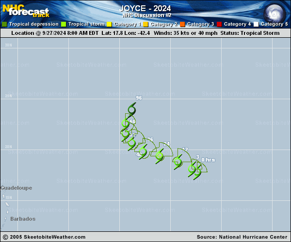
Copy of official data Tropical Storm Joyce Discussion Number 2 NWS National Hurricane Center Miami FL AL112024 500 PM AST Fri Sep 27 2024 Deep convection has increased and become more concentrated near the center of Joyce this afternoon. A cold dense overcast has developed and expanded over the low-level center of the tropical cyclone. As a result, the latest satellite intensity estimates have risen, and the initial intensity is brought up to 45 kt. This is consistent with a T3.0/45-kt Dvorak classification from TAFB, as well as a blend of recent UW-CIMSS objective estimates that range from 36-52 kt. Additional near-term strengthening is possible while Joyce remains in an environment of strong upper-level divergence and moderate shear over warm SSTs. However, the storm is forecast to encounter increasing shear and a progressively drier mid-level environment during the next couple of days, which should induce a weakening trend later this weekend and into early next week. The updated NHC intensity forecast peaks at 55 kt in 12 h, with gradual weakening shown thereafter based on the less favorable environmental conditions that are anticipated. Simulated satellite imagery from the latest ECMWF run shows Joyce maintaining organized convection through Monday, but the GFS suggests it could degenerate to a remnant low even sooner. This forecast shows Joyce degenerating into a post-tropical remnant low in 72 h and dissipating by day 5, but future timing changes may be necessary. The storm continues to move northwestward (305/11 kt) around the southwestern periphery of a low- to mid-level ridge over the eastern Atlantic. A slight turn toward the west-northwest is expected during the next day or two, along with a slower forward speed as the steering currents weaken. There is more spread in the track guidance thereafter, with some model disagreement about whether and how quickly the storm turns northward ahead of an upper trough over the central Atlantic. For now, the NHC track forecast is shifted slightly to the left and is a bit slower between 48-72 h, following the latest HCCA and and TVCA trends. FORECAST POSITIONS AND MAX WINDS INIT 27/2100Z 18.6N 44.0W 45 KT 50 MPH 12H 28/0600Z 19.1N 45.3W 55 KT 65 MPH 24H 28/1800Z 19.5N 47.1W 50 KT 60 MPH 36H 29/0600Z 20.1N 48.5W 45 KT 50 MPH 48H 29/1800Z 20.7N 49.5W 40 KT 45 MPH 60H 30/0600Z 21.4N 49.9W 35 KT 40 MPH 72H 30/1800Z 22.0N 49.8W 30 KT 35 MPH...POST-TROP/REMNT LOW 96H 01/1800Z 23.0N 49.5W 30 KT 35 MPH...POST-TROP/REMNT LOW 120H 02/1800Z...DISSIPATED $$ Forecaster Reinhart |