Official Discussion issued by the National Hurricane Center
Isaac (AL102024) DATA RELEASED: 9/26/2024 9:00:00 AM UTC
|
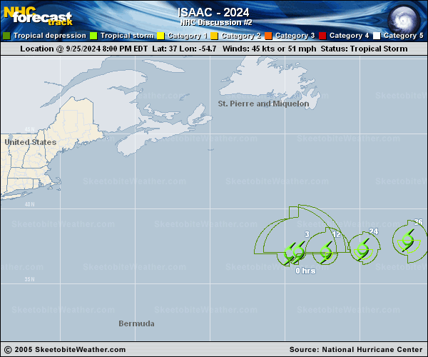
Copy of official data Tropical Storm Isaac Discussion Number 2 NWS National Hurricane Center Miami FL AL102024 500 AM AST Thu Sep 26 2024 Isaac's structure on satellite looks fairly healthy for a high-latitude tropical cyclone. There are plenty of curved banding features rotating around the estimated center on IR satellite, matched by a recent AMSR2 microwave pass also showing convective banding. While the cloud top temperatures are not that cold, only -50 to -60 C, that is rather typical for a tropical cyclone along the axis of an upper-level trough with a depressed tropopause. Based on the earlier scatterometer wind data, plus a DMINT estimate from the AMSR2 pass of 46 kt, the initial intensity is held at 45 kt this advisory. The tropical storm is continuing eastward this morning at 90/10 kt. This general motion, albeit with a gradual turn more east-northeastward is expected over the next several days as Isaac slowly accelerates under the influence of mid-level ridging to the southeast of the storm. The track guidance is in pretty good agreement in the short-term. However, differences primarily in the along-track direction begin to be evident beyond 48 h, which could ultimately play a role in more notable across-track differences shown between the GFS and ECMWF solutions by early next week. For now, the NHC track forecast is very similar to the previous track forecast, and favors a solution very similar to the HFIP corrected consensus approach (HCCA) and ECMWF track. Given the storm's healthy current structure, there is an opportunity for it to intensify over the next couple of days. During this time span, sea-surface temperatures (SSTs) hover between 26-27 C, colder than normal upper-level temperatures should aid tropospheric instability, and vertical wind shear is forecast to remain in the 15-20 kt range, in the same direction as the storm motion. The simulated IR imagery from the latest ECMWF and GFS runs also show Isaac attempting to clear out an eye occasionally in the 36-60 h period. These signals suggest that Isaac could become a hurricane, and that is now explicitly reflected in the latest NHC forecast, which is very close to the latest HCCA consensus aid. After 60 h, shear increases markedly as SSTs also decrease, which should lead to weakening, and Isaac is forecast to become post-tropical sometime near the end of the forecast as it passes by to the north of the Azores. FORECAST POSITIONS AND MAX WINDS INIT 26/0900Z 37.1N 52.8W 45 KT 50 MPH 12H 26/1800Z 37.2N 50.9W 50 KT 60 MPH 24H 27/0600Z 37.6N 48.1W 55 KT 65 MPH 36H 27/1800Z 38.3N 44.9W 60 KT 70 MPH 48H 28/0600Z 39.4N 41.2W 65 KT 75 MPH 60H 28/1800Z 40.5N 37.9W 65 KT 75 MPH 72H 29/0600Z 41.8N 34.0W 60 KT 70 MPH 96H 30/0600Z 43.0N 27.2W 55 KT 65 MPH 120H 01/0600Z 43.4N 19.4W 50 KT 60 MPH...POST-TROP/EXTRATROP $$ Forecaster Papin |