Official Discussion issued by the National Hurricane Center
(AL092024) DATA RELEASED: 9/23/2024 9:00:00 PM UTC
|
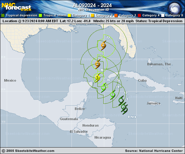
Copy of official data Potential Tropical Cyclone Nine Discussion Number 2 NWS National Hurricane Center Miami FL AL092024 500 PM EDT Mon Sep 23 2024 Showers and thunderstorms associated with the disturbance are gradually becoming better organized this afternoon, although the convection is mostly confined to the eastern portion of the circulation. Scatterometer winds and aircraft data indicate the disturbance still lacks a well-defined center, with very light winds noted on the west side of the broad, elongated circulation. The scatterometer data did show stronger winds near the convection on the east side, and based on this along with the aircraft winds, the initial intensity is raised to 30 kt for this advisory. The estimated initial motion is north-northwestward (345/6 kt), but the disturbance should turn more northwestward during the next day or so. The NHC forecast shows the center of the system passing between the Yucatan Peninsula and the western tip of Cuba late Tuesday night, then moving into the southern Gulf of Mexico on Wednesday. From there, the flow between a deep-layer trough over the central United States and a ridge over the western Atlantic should cause the system to accelerate northward to north-northeastward across the eastern Gulf of Mexico and toward the northeastern Gulf Coast and Florida Panhandle through Thursday. The track guidance is very tightly clustered on this solution, and the official NHC forecast is essentially an update of the previous one. The moderate southwesterly shear over the disturbance is expected to diminish over the next day or two, which should allow the system to become better organized and consolidate over deep, warm waters in a very moist environment. Once the system develops an inner core, these conditions should allow it to significantly strengthen. The NHC forecast still calls for the system to become a hurricane on Wednesday, with continued intensification thereafter while it moves over the eastern Gulf of Mexico. Once again, the statistical RI guidance (SHIPS and DTOPS) show a 65-kt increase in 72 h is very likely, and the updated NHC forecast now explicitly shows the system reaching major hurricane intensity on Thursday. This intensity forecast still lies below the consensus aids, with the regional hurricane models and the GFS showing even more deepening. Note that the system is expected to grow in size while it traverses the Gulf. Thus, the storm surge, wind, and rainfall impacts will extend well away from the center, particularly to the east of the system. In addition, the fast forward speed as it approaches the coast will likely result in farther inland penetration of gusty winds over parts of the southeastern United States after landfall. KEY MESSAGES: 1. The disturbance is forecast to intensify and be near hurricane strength when it reaches the far northwestern Caribbean Sea Tuesday night. Tropical storm conditions are expected over portions of western Cuba and the northeastern coast of the Yucatan Peninsula with hurricane conditions possible. 2. The system is expected to intensify into a major hurricane before it approaches the northeastern Gulf Coast on Thursday. While it is too soon to pinpoint the exact location and magnitude of impacts, the potential for life-threatening storm surge and damaging hurricane-force winds along the coast of the Florida Panhandle and the Florida west coast is increasing. Storm Surge and Hurricane Watches will likely be issued for a portion of that area tonight or Tuesday morning, and residents should ensure they have their hurricane plan in place. 3. Potential Tropical Cyclone Nine will bring heavy rain to portions of the western Caribbean which may lead to flooding and possible mudslides in western Cuba. FORECAST POSITIONS AND MAX WINDS INIT 23/2100Z 18.1N 82.2W 30 KT 35 MPH...POTENTIAL TROP CYCLONE 12H 24/0600Z 19.0N 83.0W 35 KT 40 MPH...TROPICAL CYCLONE 24H 24/1800Z 19.9N 84.2W 45 KT 50 MPH 36H 25/0600Z 21.1N 85.4W 55 KT 65 MPH 48H 25/1800Z 23.0N 86.0W 75 KT 85 MPH 60H 26/0600Z 25.4N 85.5W 90 KT 105 MPH 72H 26/1800Z 28.9N 84.5W 100 KT 115 MPH 96H 27/1800Z 35.5N 84.5W 30 KT 35 MPH...POST-TROP/INLAND 120H 28/1800Z 39.5N 88.5W 20 KT 25 MPH...POST-TROP/INLAND $$ Forecaster Reinhart |