Official Discussion issued by the National Hurricane Center
(AL052024) DATA RELEASED: 8/12/2024 3:00:00 AM UTC
|
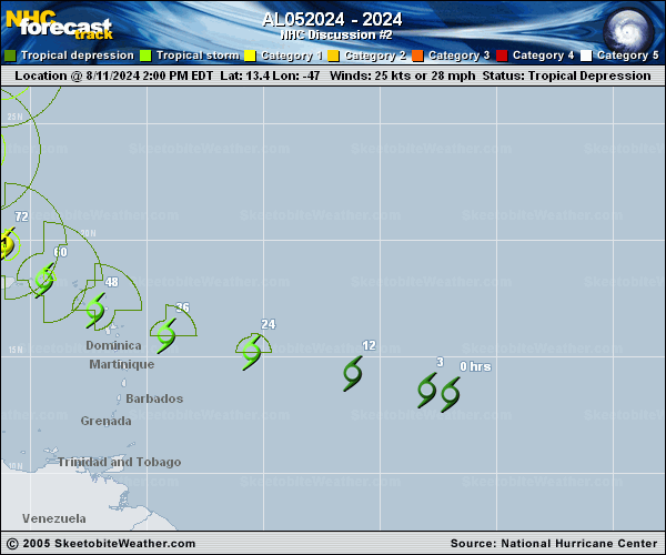
Copy of official data Potential Tropical Cyclone Five Discussion Number 2 NWS National Hurricane Center Miami FL AL052024 1100 PM AST Sun Aug 11 2024 The system remains very broad and the deep convection is still not well organized, and data from a partial ASCAT pass suggest that a well-defined circulation has not yet formed. Given the lack of increase in organization of the cloud pattern, the current intensity is held at 25 kt for this advisory. The disturbance is expected to pass near or over data buoy 41040 soon, which could help better assess the status of the system. Although the center is not well-defined, the system appears to be continuing its fast west-northwestward motion at around 285/20 kt. A mid-level ridge is forecast to remain in place to the north of the potential tropical cyclone for the next 48 hours, which should more or less maintain the current heading during that period. In the 2 to 3 day time frame, a mid-tropospheric trough moving off the U.S. east coast should cause the system to turn northward to the north of the Greater Antilles. Later in the forecast period a turn toward the north-northeast, ahead of the trough, is anticipated. The NHC forecast track is just a little to the left of the previous one during the next 48 hours, and is close to the latest model consensus. It should again be noted that forecast tracks for potential tropical cyclones are inherently more uncertain than usual because of the greater uncertainty in the initial center position. The disturbance is currently being affected by some easterly vertical wind shear which is probably inhibiting its initial development and intensification. The shear is likely to weaken soon and the thermodynamic environment is expected to become more conducive over the next few days. The official forecast calls for intensification in general agreement with the intensity model consensus. Key Messages: 1. The disturbance is expected to become a tropical storm before reaching the Leeward Islands, where Tropical Storm Watches are in effect. Tropical storm conditions could begin on Tuesday for portions of the area. 2. Heavy rainfall may result in locally considerable flash flooding and mudslides in portions of the northern Leeward Islands Tuesday and Wednesday, and into Puerto Rico Wednesday through Thursday. 3. Additional watches or warnings will likely be required for the islands of the northeastern Caribbean, including Puerto Rico, by early Monday, and interests in these locations should monitor the progress of this system. FORECAST POSITIONS AND MAX WINDS INIT 12/0300Z 14.1N 50.1W 25 KT 30 MPH...POTENTIAL TROP CYCLONE 12H 12/1200Z 14.8N 53.9W 30 KT 35 MPH...POTENTIAL TROP CYCLONE 24H 13/0000Z 15.6N 58.0W 35 KT 40 MPH...TROPICAL CYCLONE 36H 13/1200Z 16.2N 61.0W 40 KT 45 MPH 48H 14/0000Z 17.4N 63.7W 50 KT 60 MPH 60H 14/1200Z 18.7N 65.6W 55 KT 65 MPH 72H 15/0000Z 20.3N 66.8W 65 KT 75 MPH 96H 16/0000Z 24.5N 67.7W 85 KT 100 MPH 120H 17/0000Z 28.5N 65.9W 95 KT 110 MPH $$ Forecaster Pasch |