Official Discussion issued by the National Hurricane Center
(AL012024) DATA RELEASED: 6/17/2024 10:00:00 PM UTC
|
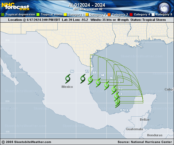
Copy of official data Potential Tropical Cyclone One Discussion Number 2 NWS National Hurricane Center Miami FL AL012024 1000 PM CDT Mon Jun 17 2024 Satellite images show the large spinning low pressure area centered over the Bay of Campeche, with lots of convective banding noted over Yucatan. While dropsondes from an earlier Air Force Reserve Hurricane Hunter survey mission showed that the pressure had fallen to about 999 mb, there are still no signs of a well-defined center, with multiple smaller circulations within the larger gyre. Thus, the low remains a potential tropical cyclone for this advisory. The system has been moving northward at about 6 kt. This general motion should continue for a day or so, followed by a west-northwestward turn due to a mid-level ridge building over the northern Gulf Coast, bringing the low near northeastern Mexico in a couple of days. The model guidance is in good agreement on this track, and little change was made to the previous forecast, with the latest NHC track lying a bit north of the model consensus. While the low pressure area remains quite broad, a fair number of the regional hurricane models are suggestive that low could eventually contract in a low-shear, very warm water environment. This isn't too difficult to believe as the overall circulation looks better organized than earlier today, but will likely take some time to strengthen due to the sprawling nature of the disturbance. Model guidance has trended upward since the last cycle, and the NHC intensity forecast is a little higher than the last one. It should be noted that regardless of the exact track of the low, we expect this system to have a large area of heavy rains, moderate coastal flooding and tropical-storm-force winds well north of the center. The official wind speed probabilities are likely underestimating the chances of tropical-storm-force winds along the Texas coast because of the aclimatologically large and asymmetric area of strong winds on the northern side of the circulation. Key Messages: 1. Users are reminded not to focus on the exact forecast track of this system. The disturbance is very large with rainfall, coastal flooding, and wind impacts likely to occur far from the center along the coasts of Texas and northeastern Mexico. 2. Rainfall associated with Potential Tropical Cyclone One will impact large regions of Central America, northeastern Mexico and South Texas. This rainfall will likely produce considerable flash and urban flooding along with new and renewed river flooding. Mudslides are also possible in areas of higher terrain across Central America into northeast Mexico. 3. Moderate coastal flooding is likely along much of the Texas Coast beginning early Tuesday and continuing through midweek. 4. Tropical storm conditions are possible beginning Wednesday over portions of northeastern Mexico and the Texas coast south of Port OG��Connor, where a Tropical Storm Watch remains in effect. FORECAST POSITIONS AND MAX WINDS INIT 18/0300Z 20.8N 93.0W 35 KT 40 MPH...POTENTIAL TROP CYCLONE 12H 18/1200Z 21.6N 92.8W 35 KT 40 MPH...POTENTIAL TROP CYCLONE 24H 19/0000Z 22.6N 93.6W 40 KT 45 MPH...TROPICAL CYCLONE 36H 19/1200Z 23.2N 95.3W 40 KT 45 MPH...TROPICAL CYCLONE 48H 20/0000Z 23.5N 96.9W 45 KT 50 MPH...TROPICAL CYCLONE 60H 20/1200Z 23.7N 98.1W 40 KT 45 MPH...INLAND 72H 21/0000Z 23.8N 99.5W 25 KT 30 MPH...INLAND 96H 22/0000Z...DISSIPATED $$ Forecaster Blake |