Official Discussion issued by the National Hurricane Center
(AL102024) DATA RELEASED: 9/30/2024 3:00:00 PM UTC
|
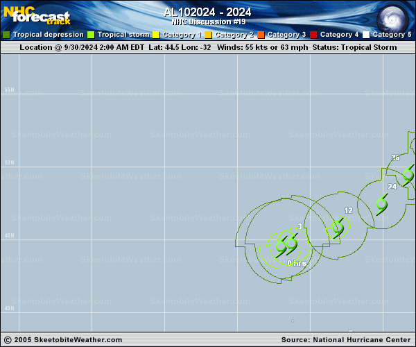
Copy of official data Post-Tropical Cyclone Isaac Discussion Number 19 NWS National Hurricane Center Miami FL AL102024 300 PM GMT Mon Sep 30 2024 Geostationary satellite data this morning indicates that Isaac has completed its transition to a Post-Tropical Extratropical Low and this will be the last NHC advisory. The remaining moderate-to-deep convection has sheared off to the northeast as stable stratocumulus clouds have fully infiltrated its low-level circulation from the west. The initial intensity has been lowered to 50 kt blending the latest subjective and objective measurements. The post-tropical cyclone is still moving east-northeastward at about 065/15 kt. A subtle turn to the northeast is still expected over the next couple of days as the cyclone remains embedded in the mid-latitude westerlies. The guidance has shifted a bit east of the prior forecast track, partially a reflection of the more eastward initial position, and the NHC track was nudged in that direction. Over the forecast period, the cyclone is expected to slowly weaken, lacking baroclinic support for much non-tropical development. The low should ultimately dissipate in the far North Atlantic to the west of Ireland before the end of the week. Additional information on this system can be found in High Seas Forecasts issued by Meteo France and the the UK Met Office. Links to each product are provided below: Meteo France: WMO header FQNT50 LFPW and available on the web at www.meteofrance.com/previsions-meteo-marine/bulletin/grandlarge/ metarea2. UK Met Office: WMO header FQNT21 EGRR and on the web at metoffice.gov.uk/weather/specialist-forecasts/coast-and-sea/high- seas-forecast/. FORECAST POSITIONS AND MAX WINDS INIT 30/1500Z 44.8N 29.1W 50 KT 60 MPH...POST-TROP/EXTRATROP 12H 01/0000Z 46.0N 26.2W 45 KT 50 MPH...POST-TROP/EXTRATROP 24H 01/1200Z 47.6N 23.6W 40 KT 45 MPH...POST-TROP/EXTRATROP 36H 02/0000Z 49.3N 22.0W 35 KT 40 MPH...POST-TROP/EXTRATROP 48H 02/1200Z 50.6N 20.7W 35 KT 40 MPH...POST-TROP/EXTRATROP 60H 03/0000Z 52.0N 19.3W 35 KT 40 MPH...POST-TROP/EXTRATROP 72H 03/1200Z 54.0N 17.5W 30 KT 35 MPH...POST-TROP/EXTRATROP 96H 04/1200Z...DISSIPATED $$ Forecaster Papin |