Official Discussion issued by the National Hurricane Center
Isaac (AL102024) DATA RELEASED: 9/30/2024 9:00:00 AM UTC
|
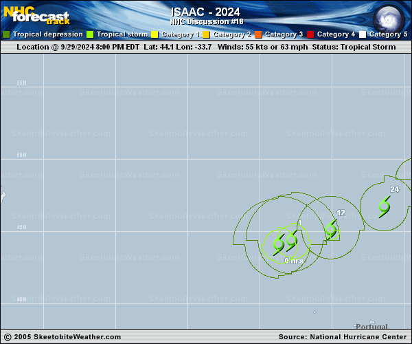
Copy of official data Tropical Storm Isaac Discussion Number 18 NWS National Hurricane Center Miami FL AL102024 900 AM GMT Mon Sep 30 2024 Isaac continues to show signs of transitioning into an extratropical cyclone. The central convection has mostly dissipated, and the system is taking on more of a frontal appearance, with a zonally-oriented cloud and rain shield over the cyclone's northern semicircle. The current intensity is kept at 55 kt in accordance with a Dvorak estimate from TAFB, although this is somewhat uncertain since Isaac no longer appears to be a true tropical cyclone. The cyclone continues to move east-northeastward or at about 060/13 kt within a southern branch of the mid-latitude westerlies. Isaac is expected to turn toward the northeast during the next couple of days as it approaches a shortwave ridge just west of the British Isles. The official track forecast has been nudged only slightly eastward in the 2-3 day time frame, towards the latest corrected dynamical model consensus. Isaac is moving over cool waters and should complete its extratropical transition today. The global models suggest that the system will gradually weaken during the next few days as it becomes absorbed within a larger low over the North Atlantic. The official intensity forecast is similar to the previous NHC prediction. FORECAST POSITIONS AND MAX WINDS INIT 30/0900Z 44.7N 31.3W 55 KT 65 MPH 12H 30/1800Z 45.8N 28.1W 50 KT 60 MPH...POST-TROP/EXTRATROP 24H 01/0600Z 47.4N 25.1W 45 KT 50 MPH...POST-TROP/EXTRATROP 36H 01/1800Z 49.4N 23.3W 40 KT 45 MPH...POST-TROP/EXTRATROP 48H 02/0600Z 51.3N 22.3W 40 KT 45 MPH...POST-TROP/EXTRATROP 60H 02/1800Z 53.0N 21.2W 35 KT 40 MPH...POST-TROP/EXTRATROP 72H 03/0600Z 54.5N 20.0W 30 KT 35 MPH...POST-TROP/EXTRATROP 96H 04/0600Z...DISSIPATED $$ Forecaster Pasch |