Official Discussion issued by the National Hurricane Center
Gordon (AL072024) DATA RELEASED: 9/15/2024 9:00:00 PM UTC
|
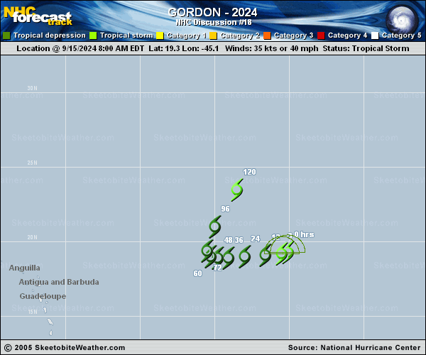
Copy of official data Tropical Depression Gordon Discussion Number 18 NWS National Hurricane Center Miami FL AL072024 500 PM AST Sun Sep 15 2024 Gordon's center remains well displaced to the west of the area of deep convection. There recently was a convective burst near the center, and it remains to be seen if this is an intermittent pulse of convection or if the system will try to maintain convection. Subjective and objective Dvorak estimates have decreased between 25 to 35 kt. Using an average of these estimates, the intensity for this advisory is set to 30 kt, and Gordon has weakened into a tropical depression. The cyclone continues to move west-southwestward, with a current motion estimate of 260/7 kt. Gordon is being steered by a mid-level ridge to to the north. The steering flow is expected to weaken as the ridge to the north becomes less pronounced, which should result in Gordon slowing down considerably. By late in the forecast period, a trough develops to the west-northwest of Gordon. This is expected to cause the tropical cyclone to turn toward the north-northeast. The official track forecast is similar to the previous one, nudged slightly to the right and a little faster towards the end of the period near the HFIP corrected consensus. Gordon continues to experience strong westerly vertical wind shear and is within fairly stable airmass. It still remains possible that the the system could degenerate into a remnant low, as it struggles to produce convection. The environmental conditions improve towards the end of the forecast period that depicts that the system could re-strengthen. The current intensity forecast is similar to the previous forecast but does show Gordon becoming a tropical storm again towards the end of the period, if it can survive the next few days. FORECAST POSITIONS AND MAX WINDS INIT 15/2100Z 19.2N 46.1W 30 KT 35 MPH 12H 16/0600Z 19.1N 47.2W 30 KT 35 MPH 24H 16/1800Z 19.0N 48.4W 30 KT 35 MPH 36H 17/0600Z 19.0N 49.2W 30 KT 35 MPH 48H 17/1800Z 19.2N 49.6W 30 KT 35 MPH 60H 18/0600Z 19.5N 49.9W 30 KT 35 MPH 72H 18/1800Z 20.0N 50.0W 30 KT 35 MPH 96H 19/1800Z 22.2N 49.1W 35 KT 40 MPH 120H 20/1800Z 24.9N 47.6W 35 KT 40 MPH $$ Forecaster Kelly |