Official Discussion issued by the National Hurricane Center
Ernesto (AL052024) DATA RELEASED: 8/16/2024 3:00:00 AM UTC
|
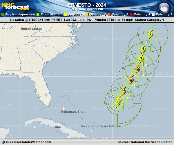
Copy of official data Hurricane Ernesto Discussion Number 18 NWS National Hurricane Center Miami FL AL052024 1100 PM AST Thu Aug 15 2024 Ernesto has been strengthening this evening. Data from an Air Force Hurricane Hunter aircraft indicate that the minimum pressure has fallen to about 968 mb, and a blend of the peak flight-level and SFMR winds support increasing the initial intensity to 85 kt. This makes Ernesto a category 2 hurricane on the Saffir-Simpson Hurricane Wind Scale. Ernesto has a ragged eye and a large wind field, with the highest winds occurring in the northeast quadrant. Ernesto is moving north-northeastward at 12 kt in the flow between a high pressure system over the central Atlantic and a large-scale trough off the U.S. east coast. This general motion is expected to continue for the next day or two, bringing the hurricane near or over Bermuda on Saturday. Around that time, the trough is expected to lift out, leaving Ernesto in weaker steering currents. As a result, a slower and likely more erratic motion to the north or north-northeast is forecast over the weekend. Another trough is expected to approach the cyclone late in the weekend, and that should cause an accelerated motion to the northeast near or east of Atlantic Canada early next week. The NHC track forecast is a touch to the east and a little slower than the previous one through its passage near Bermuda to come into better agreement with the latest consensus aids. It seems likely that Ernesto will strengthen some more during the next 12 to 24 hours as it is expected to remain in conducive environmental conditions of low wind shear, upper-level diffluence, a relatively moist airmass, and over warm waters during that time. Thereafter, increasing vertical wind shear and gradually cooler waters should cause a slow weakening trend. However, baroclinic influences could offset some of the weakening, which is why the official forecast shows little change in strength during the 48- to 72-hour time frame. Ernesto is forecast to complete extratropical transition by day 5, when it will likely be embedded within the mid-latitude westerlies. The NHC intensity forecast lies near the high end of the guidance, in best agreement with the HCCA model. Key Messages: 1. Ernesto is moving toward Bermuda, and it is expected to bring a prolonged period of strong winds and storm surge on Bermuda from Friday afternoon through Saturday night. A hurricane warning is in effect for the island, and preparations to protect life and property should be rushed to completion. 2. Rainfall associated with Ernesto is expected to begin to affect Bermuda overnight and may result in flash flooding Friday through this weekend. 3. Even though Ernesto is forecast to remain well offshore the U.S. East Coast, swells generated by the hurricane are expected to affect the area through the weekend. Beach goers should be aware of a significant risk of life-threatening surf and rip currents, and stay out of the water if advised by lifeguards. Surf and rip currents are also possible on the Turks and Caicos, the Bahamas, Bermuda, and Atlantic Canada during the next few days. FORECAST POSITIONS AND MAX WINDS INIT 16/0300Z 27.1N 68.1W 85 KT 100 MPH 12H 16/1200Z 28.5N 67.1W 95 KT 110 MPH 24H 17/0000Z 30.4N 65.9W 95 KT 110 MPH 36H 17/1200Z 32.1N 65.1W 85 KT 100 MPH 48H 18/0000Z 33.5N 64.8W 80 KT 90 MPH 60H 18/1200Z 35.4N 64.1W 80 KT 90 MPH 72H 19/0000Z 38.2N 62.6W 80 KT 90 MPH 96H 20/0000Z 45.6N 54.6W 70 KT 80 MPH 120H 21/0000Z 51.0N 36.7W 50 KT 60 MPH...POST-TROP/EXTRATROP $$ Forecaster Cangialosi |