Official Discussion issued by the National Hurricane Center
Helene (AL092024) DATA RELEASED: 9/27/2024 3:00:00 PM UTC
|
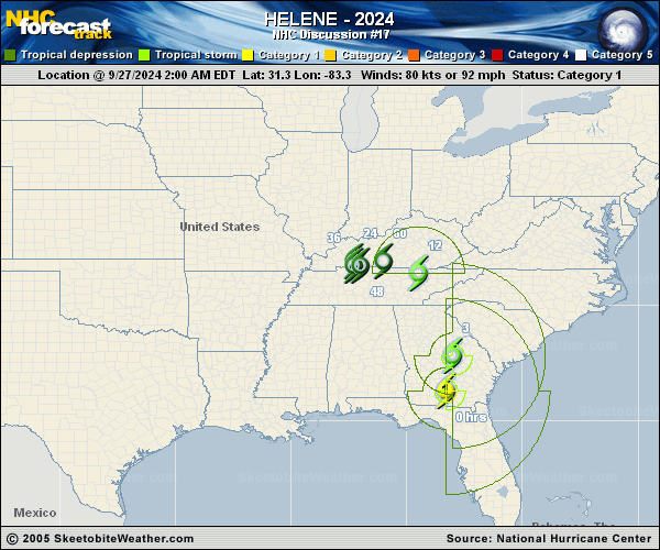
Copy of official data Tropical Storm Helene Discussion Number 17 NWS National Hurricane Center Miami FL AL092024 1100 AM EDT Fri Sep 27 2024 Helene has been racing northward and the low-level center is now located over the southern Appalachians. Strong bands of heavy rain and very gusty winds continue off and along the South Carolina coast. In addition, wind gusts to around hurricane force have been occurring this morning in portions of northeastern Georgia and the western portions of the Carolinas, especially in areas of higher terrain. The initial intensity is set at 40 kt, and these sustained winds are likely occurring off the south Carolina coast and over the Appalachians. The main hazard is the very heavy rainfall ongoing over portions of the southeastern U.S., which is causing historic and life-threatening flooding. Helene is expected to move slower to the northwest later today and then stall over the Tennessee Valley tonight and through the weekend as it merges with a mid- to upper-level low. This merger will also lead to extratropical transition, which is expected to occur later today. The expected slow motion could result in significant flooding over the Ohio and Tennessee Valleys, and over the southern Appalachians through the weekend. KEY MESSAGES: 1. Historic, catastrophic and life-threatening flash and urban flooding, including numerous significant landslides, will continue across portions of the Southern Appalachians through this evening. Widespread significant river flooding is ongoing, some of which will be major to record breaking. 2. Damaging wind gusts will continue over portions of Georgia, the Carolinas, Tennessee, and Kentucky today, particularly over the higher terrain of the southern Appalachians. 3. There is a possibility of long-duration power outages in portions of the southeast U.S. If you use a generator after the storm, be sure it is placed outside at least 20 feet away from doors, windows, and garages to avoid deadly carbon monoxide poisoning. FORECAST POSITIONS AND MAX WINDS INIT 27/1500Z 35.1N 83.8W 40 KT 45 MPH 12H 28/0000Z 37.3N 85.6W 30 KT 35 MPH...POST-TROP/EXTRATROP 24H 28/1200Z 37.5N 86.5W 25 KT 30 MPH...POST-TROP/EXTRATROP 36H 29/0000Z 37.5N 86.4W 20 KT 25 MPH...POST-TROP/EXTRATROP 48H 29/1200Z 37.5N 86.1W 20 KT 25 MPH...POST-TROP/EXTRATROP 60H 30/0000Z 37.6N 85.7W 20 KT 25 MPH...POST-TROP/EXTRATROP 72H 30/1200Z...DISSIPATED $$ Forecaster Cangialosi/Rosado |