Official Discussion issued by the National Hurricane Center
Gordon (AL072024) DATA RELEASED: 9/15/2024 3:00:00 PM UTC
|
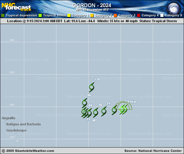
Copy of official data Tropical Storm Gordon Discussion Number 17 NWS National Hurricane Center Miami FL AL072024 1100 AM AST Sun Sep 15 2024 Gordon's center remains displaced at least 120 n mi to the west of a ragged-looking area of deep convection. Using a shear pattern from satellite imagery, Dvorak data T-numbers correspond to an intensity below tropical storm strength. However,scatterometer data, which did not completely sample the circulation, suggest that the system's intensity may still be close to to 35 kt, so Gordon is kept at tropical storm status for this advisory. The cyclone continues to move west-southwestward, with a current motion estimate of 250/8 kt. Gordon is being steered by a mid-level high pressure system to its north and northwest. This high is forecast to gradually weaken which should result in a slowing of the cyclone's forward speed over the next few days. In 3-4 days, the high is predicted to shift farther west, resulting in a turn toward the north. By late in the forecast period, a broad trough becomes established to the west-northwest of Gordon. This is expected to cause the tropical cyclone to turn toward the north-northeast. The official track forecast is similar to the previous one and is reasonably close to the latest HFIP Corrected Consensus. Gordon has been experiencing strong westerly vertical wind shear for the past couple of days, associated with a large upper-level trough over the eastern Atlantic. The global models show this trough moving eastward, away from the tropical cyclone. As a result, there may be some relaxation of the shear over the next several days. Although Gordon has been disrupted so much by the shear that it could degenerate into a remnant low soon, the more conducive upper-level environment predicted by the dynamical guidance could result in some restrengthening. This is also indicated by the latest SHIPS model output. As a compromise, the official forecast shows little change in strength through the forecast period. FORECAST POSITIONS AND MAX WINDS INIT 15/1500Z 19.2N 45.5W 35 KT 40 MPH 12H 16/0000Z 19.1N 46.6W 30 KT 35 MPH 24H 16/1200Z 19.0N 48.0W 30 KT 35 MPH 36H 17/0000Z 18.9N 49.1W 30 KT 35 MPH 48H 17/1200Z 18.9N 49.8W 30 KT 35 MPH 60H 18/0000Z 19.0N 50.3W 30 KT 35 MPH 72H 18/1200Z 19.4N 50.5W 30 KT 35 MPH 96H 19/1200Z 21.0N 50.0W 30 KT 35 MPH 120H 20/1200Z 23.5N 48.5W 35 KT 40 MPH $$ Forecaster Pasch |