Official Discussion issued by the National Hurricane Center
Kirk (AL122024) DATA RELEASED: 10/3/2024 9:00:00 AM UTC
|
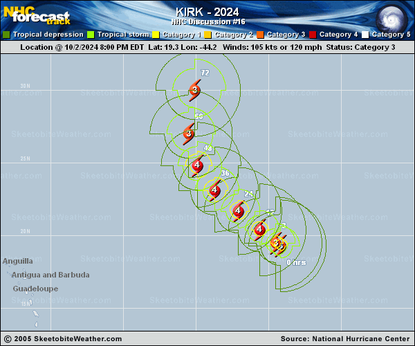
Copy of official data Hurricane Kirk Discussion Number 16 NWS National Hurricane Center Miami FL AL122024 500 AM AST Thu Oct 03 2024 After going through a period of rapid intensification, Kirk appears to have stopped intensifying, at least temporarily, and there are signs in satellite imagery that a dry slot has wrapped into the circulation. Subjective final-T numbers have decreased slightly from TAFB and SAB, and the initial intensity is set at 105 kt, near the CI numbers. Kirk continues to move northwestward (315/9 kt), which should continue for the next 36 hours while the hurricane moves along the southwestern periphery of the subtropical high. After 36 hours, Kirk is forecast to recurve between the high and a deep-layer trough over the western/central Atlantic, eventually moving northeastward by late Sunday or Monday. There is lower-than-normal spread among the track guidance, including the global model ensembles, and overall the new NHC track prediction is not changed much from the previous advisory. The hurricane is expected to move through a moist, low-shear environment for the next 36 hours or so, with sea surface temperatures actually warming by a degree or two up to 30 deg Celsius. If Kirk can avoid further intrusions of dry air into the eye, then the environment should be able to support strengthening to category 4 strength. The NHC intensity forecast is near the top end of the guidance during the short term. After 36 hours, increasing deep-layer shear is likely to induce a gradual weakening trend, but interaction with a baroclinic energy source should help the storm to maintain hurricane-force winds through the end of the forecast period. Based on thickness fields from the global models, Kirk is now forecast to be extratropical by day 5. Kirk is expected to grow in size and send out ocean swells across the central and western Atlantic. These swells will likely increase the risk of dangerous surf and rip currents along the Leeward Islands by Friday, Bermuda and the Greater Antilles by Saturday, and the U.S. East Coast and the Bahamas by Sunday. FORECAST POSITIONS AND MAX WINDS INIT 03/0900Z 20.0N 45.0W 105 KT 120 MPH 12H 03/1800Z 20.8N 46.2W 115 KT 130 MPH 24H 04/0600Z 22.1N 47.7W 120 KT 140 MPH 36H 04/1800Z 23.5N 49.1W 120 KT 140 MPH 48H 05/0600Z 25.4N 50.1W 115 KT 130 MPH 60H 05/1800Z 28.0N 50.3W 110 KT 125 MPH 72H 06/0600Z 31.3N 49.3W 100 KT 115 MPH 96H 07/0600Z 38.5N 42.5W 85 KT 100 MPH 120H 08/0600Z 44.7N 30.8W 75 KT 85 MPH...POST-TROP/EXTRATROP $$ Forecaster Berg |