Official Discussion issued by the National Hurricane Center
Ernesto (AL052024) DATA RELEASED: 8/15/2024 3:00:00 PM UTC
|
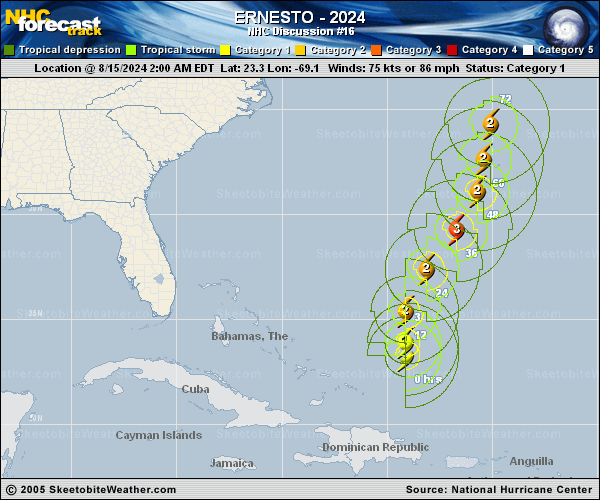
Copy of official data Hurricane Ernesto Discussion Number 16 NWS National Hurricane Center Miami FL AL052024 1100 AM AST Thu Aug 15 2024 Dry air appears to be disrupting Ernesto's attempts to become more organized. Recent microwave satellite imagery has shown a large dry slot wrapping into the center of the hurricane. An Air Force Reserve reconnaissance aircraft currently investigating Ernesto has found peak flight-level winds of 87 kt and an expanded surface wind field. Normally, this elevated wind would reduce to a surface wind speed of 75-80 kt, however, given the broad nature of the storm and lack of inner-core organization, these winds may not be mixing down as efficiently as usual. The initial intensity remains at 75 kt for this advisory. Ernesto is moving to the north at about 12 kt. The model guidance is tightly clustered and shows the hurricane turning to the northeast within a day or so while moving through a break in the subtropical ridge towards a trough located off the coast of the eastern United States. As the trough lifts by the weekend, Ernesto should slow and turn to the north-northeast or north, while approaching Bermuda on Friday night and Saturday. By the end of the weekend, Ernesto is expected to accelerate northeastward near the coast of Atlantic Canada. There have been little changes to the most recent NHC track forecast, which lies just west of the corrected consensus aid, HCCA. Model guidance is still suggesting that some continued gradual strengthening is possible in the next day or so. The deep-layer vertical wind shear is forecast to be weak to moderate, and Ernesto should be over warm waters for the next few days. However, the broad nature of the current circulation, coupled with some dry air ingestion, will likely slow the intensification rate. Ernesto is now forecast to peak at 95 kt in 24 h, which is near the top of the model guidance envelope. Beyond a day, the shear is expected to increase and induce gradually weakening, though the warm waters and positive interaction with the upper-level trough will likely allow Ernesto remain a powerful hurricane as it moves north of Bermuda. Key Messages: 1. Ernesto is expected to approach Bermuda late Friday and be near the island Saturday and Saturday night. A prolonged period of strong winds and storm surge is expected on Bermuda beginning late Friday, and a hurricane warning is in effect for the island. Preparations to protect life and property should be rushed to completion. 2. Rainfall associated with Ernesto is expected to begin to affect Bermuda later today and may result in flash flooding Friday through this weekend. 3. Even though Ernesto is forecast to remain well offshore the U.S. East Coast, swells generated by the storm are expected to reach the area during the next few days, including over the weekend. Beach goers should be aware of a significant risk of life-threatening surf and rip currents, and stay out of the water if advised by lifeguards. Surf and rip currents are also possible on the Dominican Republic, the Turks and Caicos, the Bahamas, and Bermuda during the next few days. FORECAST POSITIONS AND MAX WINDS INIT 15/1500Z 25.0N 69.2W 75 KT 85 MPH 12H 16/0000Z 26.6N 68.7W 85 KT 100 MPH 24H 16/1200Z 28.5N 67.5W 95 KT 110 MPH 36H 17/0000Z 30.3N 66.3W 90 KT 105 MPH 48H 17/1200Z 32.0N 65.5W 85 KT 100 MPH 60H 18/0000Z 33.6N 65.1W 80 KT 90 MPH 72H 18/1200Z 35.6N 64.6W 80 KT 90 MPH 96H 19/1200Z 41.6N 60.5W 80 KT 90 MPH 120H 20/1200Z 48.6N 48.1W 60 KT 70 MPH...POST-TROP/EXTRATROP $$ Forecaster Bucci/Onderlinde |