Official Discussion issued by the National Hurricane Center
Kirk (AL122024) DATA RELEASED: 10/3/2024 3:00:00 AM UTC
|
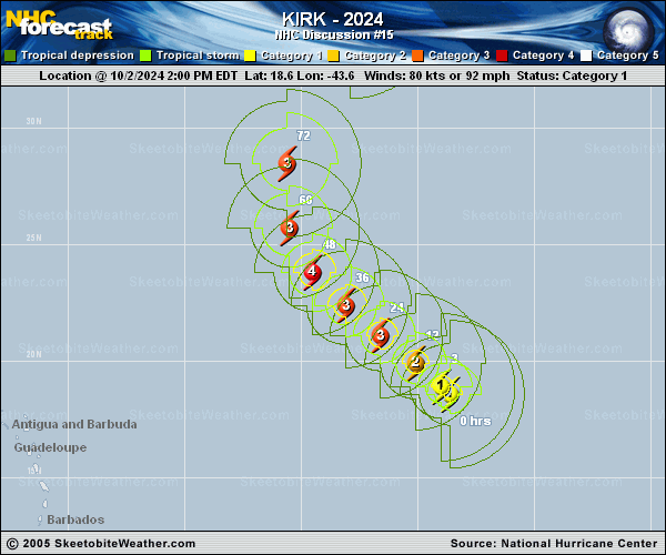
Copy of official data Hurricane Kirk Discussion Number 15 NWS National Hurricane Center Miami FL AL122024 1100 PM AST Wed Oct 02 2024 Kirk has undergone an impressive period of rapid intensification over the past 24 h. Recent satellite imagery showed a ragged eye, with multiple deep bursts of convection rotating in the eyewall. Overshooting tops are obscuring the eye now, but it would not be surprising if it clears again soon. As noted in the special advisory, the subjective Dvorak satellite estimates have climbed but were constrained. The initial intensity is nudged up to 110 kt for this advisory, closest to the T6.0 data-T number from SAB. The hurricane has strengthened 55 kt since 0300 UTC last night, which means Kirk lands at a Category 3 on the Saffir-Simpson scale. The hurricane continues to be steered by the subtropical ridge to the northwest at an estimated 310/9 kt. Little has changed in the track forecast reasoning. On Friday night or Saturday, Kirk is expected to gradually turn north-northwestward to northward and accelerate in the flow between a deep-layer trough and the weakening subtropical ridge. Later in the weekend, Kirk is expected to continue accelerating north-northeastward to northeastward. Few changes have been made to the latest official track forecast, which lie close to various consensus aids. Given Kirk's recent rapid intensification, conditions appear conducive for further strengthening during the next day or so. The short-term forecast is therefore above all of the guidance now, peaking at 130 kt in 24 h. By Friday, the vertical wind shear is expected to increase and gradually weaken Kirk through the remainder of the forecast period. As the hurricane moves more poleward, Kirk's tropical-storm-force winds are predicted to grow and send large swell westward to the northern Leeward Islands and the Bahamas over the weekend. FORECAST POSITIONS AND MAX WINDS INIT 03/0300Z 19.5N 44.5W 110 KT 125 MPH 12H 03/1200Z 20.4N 45.6W 125 KT 145 MPH 24H 04/0000Z 21.7N 47.1W 130 KT 150 MPH 36H 04/1200Z 23.1N 48.7W 125 KT 145 MPH 48H 05/0000Z 24.8N 49.9W 120 KT 140 MPH 60H 05/1200Z 27.0N 50.5W 110 KT 125 MPH 72H 06/0000Z 30.0N 50.1W 105 KT 120 MPH 96H 07/0000Z 36.8N 45.5W 90 KT 105 MPH 120H 08/0000Z 43.9N 35.2W 80 KT 90 MPH $$ Forecaster Bucci |