Official Discussion issued by the National Hurricane Center
Francine (AL062024) DATA RELEASED: 9/12/2024 4:00:00 AM UTC
|
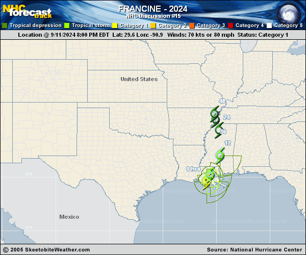
Copy of official data Tropical Storm Francine Discussion Number 15 NWS National Hurricane Center Miami FL AL062024 400 AM CDT Thu Sep 12 2024 Francine has continued to rapidly weaken overnight while moving inland across eastern Louisiana. The system is highly sheared due to its interaction with a mid- to upper-level trough to the northwest. Francine is quickly losing tropical characteristics, and surface observations indicate the surface center is located south and west of the heaviest rainfall. Tropical storm conditions, especially in gusts, continue over portions of the northern Gulf Coast within the warning area. Earlier scatterometer data showed 35-40 kt offshore winds, and the initial intensity is lowered to 40 kt. The storm has slowed down a bit and is now moving northeastward at about 10 kt. Francine is expected to turn north-northeastward and northward today, bringing the center across central and northern Mississippi. Continued weakening is expected, and tropical storm conditions along the coasts of southeastern Louisiana, Mississippi, and Alabama are likely to subside this morning as the low weakens and moves further inland. Given its degraded satellite structure, Francine is likely to degenerate to a post-tropical low as early as this morning, with dissipation forecast to occur by 48 h. An experimental cone graphic that includes inland Hurricane and Tropical Storm Watches and Warnings in the U.S. is now available on the NHC website. Due to the time needed to compile the inland watch and warning information, the experimental cone graphic will not be available as quickly as the operational cone. Once it is available, the experimental cone graphic can be found from a red weblink above the operational cone graphic at https://www.nhc.noaa.gov/graphics_at1.shtml?cone#contents. Users are encouraged to take the experimental product survey found below the experimental cone. KEY MESSAGES: 1. There is a danger of life-threatening storm surge during the next several hours for portions of the eastern Louisiana and Mississippi coastlines, where a Storm Surge Warning remains in effect. Residents in the warning area should continue to follow advice given by local officials. 2. A Tropical Storm Warning remains in effect for coastal portions of southeastern Louisiana, Mississippi, and Alabama, where tropical storm conditions could continue for the next few hours. 3. Francine will continue to bring heavy rainfall and the risk of flash and urban flooding, along with river flooding, across portions of the Lower Mississippi Valley, Tennessee Valley, and the Southeast. Locally considerable flash and urban flooding is possible today and tonight over portions of central and northern Alabama and the Florida Panhandle. FORECAST POSITIONS AND MAX WINDS INIT 12/0900Z 30.9N 90.1W 40 KT 45 MPH 12H 12/1800Z 32.6N 89.8W 30 KT 35 MPH...POST-TROP/REMNT LOW 24H 13/0600Z 34.4N 90.1W 25 KT 30 MPH...POST-TROP/EXTRATROP 36H 13/1800Z 35.1N 90.3W 20 KT 25 MPH...POST-TROP/EXTRATROP 48H 14/0600Z...DISSIPATED $$ Forecaster Reinhart |