Official Discussion issued by the National Hurricane Center
Ernesto (AL052024) DATA RELEASED: 8/15/2024 9:00:00 AM UTC
|
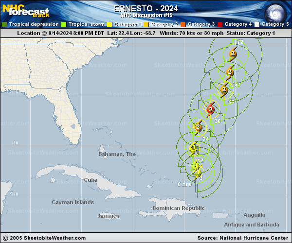
Copy of official data Hurricane Ernesto Discussion Number 15 NWS National Hurricane Center Miami FL AL052024 500 AM AST Thu Aug 15 2024 Ernesto has strengthened overnight. Satellite images show that a more symmetric area of deep convection has formed near the center, with a rather large curved band wrapping in all quadrants of the hurricane. The initial intensity is set to 75 kt, matching the TAFB and SAB estimates, though recent imagery suggests that could be a little conservative. An Air Force Reserve Hurricane Hunter Aircraft is scheduled to be in the hurricane in a few hours. Ernesto has turned northward and is moving at about 11 kt. The models remain in good agreement that the hurricane should turn to the northeast during the next day or so while moving through a break in the subtropical ridge over the western Atlantic towards a mid-latitude trough. However, the trough departs by the weekend, causing Ernesto to move slower to the north-northeast or north while the hurricane approaches Bermuda Friday night and Saturday. Later this weekend, a second trough will move across the eastern U.S., and Ernesto should accelerate northeastward early next week within the deep-layer southwesterly flow ahead of this feature. The NHC track forecast is very close to the previous one as the track guidance remains in good overall agreement. While the shear near Ernesto remains low, a large dry slot continues to wrap near the core, preventing anything other than slow intensification so far. Most of the guidance gradually intensifies the system during the next day or so as the very warm waters and light-to-moderate shear outweigh the effects of the dry air. Little change was made to the intensity forecast, and all of the guidance show this system as a large hurricane near Bermuda. There remains some indications that positive interactions with the second upper trough and warmer than normal waters should cause the system to keep much of its strength north of Bermuda, and the new forecast reflects this. All of the guidance now show Ernesto as post-tropical by 120 h, and so does the NHC forecast. Key Messages: 1. Ernesto is expected to approach Bermuda late Friday and be near the island Saturday and Saturday night. A prolonged period of strong winds and storm surge is expected on Bermuda beginning late Friday, and a hurricane warning has been issued for the island. Preparations to protect life and property should be rushed to completion. 2. Rainfall associated with Ernesto is expected to begin to affect Bermuda later today and may result in flash flooding Friday through this weekend. 3. Even though Ernesto is forecast to remain well offshore the U.S. East Coast, swells generated by the storm are expected to reach the area late this week and into the weekend. Beach goers should be aware of a significant risk of life-threatening surf and rip currents, and stay out of the water if advised by lifeguards. Surf and rip currents are also possible on the Virgin Islands, Puerto Rico, the Dominican Republic, the Turks and Caicos, and the Bahamas during the next few days. FORECAST POSITIONS AND MAX WINDS INIT 15/0900Z 23.9N 69.1W 75 KT 85 MPH 12H 15/1800Z 25.4N 69.1W 85 KT 100 MPH 24H 16/0600Z 27.4N 68.1W 95 KT 110 MPH 36H 16/1800Z 29.3N 66.7W 100 KT 115 MPH 48H 17/0600Z 31.1N 65.7W 95 KT 110 MPH 60H 17/1800Z 32.6N 65.4W 90 KT 105 MPH 72H 18/0600Z 34.3N 65.1W 90 KT 105 MPH 96H 19/0600Z 39.7N 62.3W 90 KT 105 MPH 120H 20/0600Z 47.0N 52.0W 65 KT 75 MPH...POST-TROPICAL $$ Forecaster Blake |