Official Discussion issued by the National Hurricane Center
Beryl (AL022024) DATA RELEASED: 7/2/2024 9:00:00 AM UTC
|
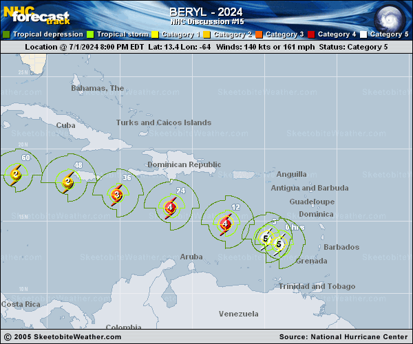
Copy of official data Hurricane Beryl Discussion Number 15 NWS National Hurricane Center Miami FL AL022024 500 AM AST Tue Jul 02 2024 Beryl remains an impressive category 5 hurricane this morning. Satellite imagery shows a well-defined eye, expanding outflow, and a prominent outer band. Overnight NOAA Hurricane Hunter aircraft data showed the minimum central pressure falling to about 935 mb, and the Tail Doppler Radar measured 170 kt of wind at about 500 m. This supports the initial intensity of 145 kt for this advisory. The hurricane is moving quickly to west-northwest at an estimated 290/19 kt. A strong subtropical ridge centered over the southern United States will continue to steer Beryl west-northwestward to westward across the central and northwestern Caribbean for the next few days. The latest track forecast has been nudged slightly to the north and lies closest to the corrected consensus aid. There is still increased uncertainty in the track forecast beyond 72 h, with the model guidance showing a large spread as Beryl emerges over the Gulf of Mexico. Beryl's intensity forecast is also rather uncertain. Model guidance all indicates that the hurricane will begin to weaken later today as Beryl encounters moderate-to-strong vertical wind shear. Later on, factors such as the possible interaction with the Jamaican elevated terrain, dry air intrusions, and the structure of the vertical wind shear will all play a role in the rate of weakening. The models show quite a wide range of solutions, with guidance between a strong tropical storm to a major hurricane while it nears the Yucatan Peninsula. The NHC forecast lies in the middle of the aids, showing Beryl as a major hurricane near Jamaica, reaching Yucatan as a hurricane in about 72 h before emerging as a tropical storm over the Gulf of Mexico. This is quite an uncertain forecast beyond a couple of days due to the aforementioned factors. Key Messages: 1. Beryl is forecast to remain a powerful hurricane as it moves across the Caribbean Sea later this week. A Hurricane Warning is in effect for Jamaica, where hurricane conditions are expected on Wednesday. A Tropical Storm Warning is also in effect for the south coast of Hispaniola, and a Hurricane Watch is now in effect for all of the Cayman Islands. 2. Heavy rainfall and flash flooding are likely over much of Jamaica on Wednesday. 3. Interests in Belize, the Yucatan Peninsula, Cuba, and the southwestern Gulf of Mexico should monitor the progress of Beryl. Additional watches and warnings will likely be required later today or Wednesday. FORECAST POSITIONS AND MAX WINDS INIT 02/0900Z 14.6N 66.9W 145 KT 165 MPH 12H 02/1800Z 15.5N 69.6W 135 KT 155 MPH 24H 03/0600Z 16.5N 73.4W 120 KT 140 MPH 36H 03/1800Z 17.4N 76.8W 105 KT 120 MPH 48H 04/0600Z 18.2N 80.2W 95 KT 110 MPH 60H 04/1800Z 18.7N 83.6W 85 KT 100 MPH 72H 05/0600Z 19.3N 86.7W 80 KT 90 MPH 96H 06/0600Z 21.2N 91.8W 55 KT 65 MPH 120H 07/0600Z 23.0N 95.5W 55 KT 65 MPH $$ Forecaster Bucci/Blake |