Official Discussion issued by the National Hurricane Center
Joyce (AL112024) DATA RELEASED: 9/30/2024 9:00:00 PM UTC
|
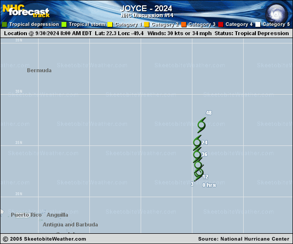
Copy of official data Tropical Depression Joyce Discussion Number 14 NWS National Hurricane Center Miami FL AL112024 500 PM AST Mon Sep 30 2024 Visible satellite imagery this afternoon depicts increasing bursts of convection just east and especially just north of the generally exposed low-level center of Joyce. This precludes downgrading Joyce to a post-tropical remnant low with this advisory, though that could happen as early as tonight if the burst does not organize. The intensity of the depression was held at 30 kt for this advisory based on continuity. Joyce has moved very little over the past 12 to 24 hours, but the current motion estimate was held at an uncertain 360/2 kt. The official forecast track shows a slow northward motion until Joyce fully dissipates within 48 h, with little change from the previous track forecast. Continued deep-layer shear and dry air encompassing Joyce is forecast to inhibit additional convection and lead to the cyclone becoming a remnant low soon. The intensity forecast remains unchanged from the previous one, showing Joyce becoming a remnant low in 12 h with dissipation in about 48 h. FORECAST POSITIONS AND MAX WINDS INIT 30/2100Z 22.7N 48.9W 30 KT 35 MPH 12H 01/0600Z 23.4N 48.9W 30 KT 35 MPH...POST-TROP/REMNT LOW 24H 01/1800Z 24.8N 48.9W 25 KT 30 MPH...POST-TROP/REMNT LOW 36H 02/0600Z 26.5N 48.9W 20 KT 25 MPH...POST-TROP/REMNT LOW 48H 02/1800Z...DISSIPATED $$ Forecaster Konarik/Blake |