Official Discussion issued by the National Hurricane Center
Gordon (AL072024) DATA RELEASED: 9/14/2024 9:00:00 PM UTC
|
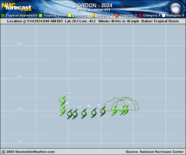
Copy of official data Tropical Storm Gordon Discussion Number 14 NWS National Hurricane Center Miami FL AL072024 500 PM AST Sat Sep 14 2024 Over the past couple of hours, the center of Gordon had been exposed to the west of the convective canopy. However, there have been recent bursts of convection closer to the center of the storm and the overall satellite presentation of the system has improved. The environment surrounding Gordon is still unfavorable, with moderate westerly vertical wind shear and a dry stable airmass continuing to have some impact on the cyclone. Gordon is likely in somewhat of a steady state, and the initial intensity remains 40 kt for this advisory. This agrees with the subjective and objective intensity estimates. The tropical storm is forecast to weaken to a depression on Sunday, as it continues to experience moderate shear and a drier and more stable airmass. Model guidance has trended weaker towards the end of the period and the intensity forecast is in fairly good agreement with the HCCA corrected consensus aids. Global models have continued to trend towards Gordon struggling to produce convection, and it is possible Gordon may degenerate into a remnant low or surface trough by the middle of the forecast period. The current forecast keeps Gordon as a tropical cyclone through the period, although this could be generous and subsequent changes may be needed in future advisories. Gordon is tracking westward at 270/9 kt, and a gradual turn toward the west-southwest with a slower forward speed is forecast over the next couple of days, in agreement with the latest track guidance. A shortwave trough approaching from the northwest of Gordon will open a weakness in the mid-level subtropical ridge and allow the tropical cyclone to turn slowly northward. The new track forecast is nearly the same as the previous forecast, except with a slightly slower forward motion. FORECAST POSITIONS AND MAX WINDS INIT 14/2100Z 20.3N 42.9W 40 KT 45 MPH 12H 15/0600Z 20.1N 44.2W 35 KT 40 MPH 24H 15/1800Z 20.0N 45.7W 30 KT 35 MPH 36H 16/0600Z 19.9N 47.2W 30 KT 35 MPH 48H 16/1800Z 19.8N 48.6W 30 KT 35 MPH 60H 17/0600Z 19.8N 49.7W 30 KT 35 MPH 72H 17/1800Z 19.9N 50.4W 30 KT 35 MPH 96H 18/1800Z 20.6N 51.0W 30 KT 35 MPH 120H 19/1800Z 21.6N 51.0W 30 KT 35 MPH $$ Forecaster Kelly/Mahoney |