Official Discussion issued by the National Hurricane Center
Francine (AL062024) DATA RELEASED: 9/11/2024 10:00:00 PM UTC
|
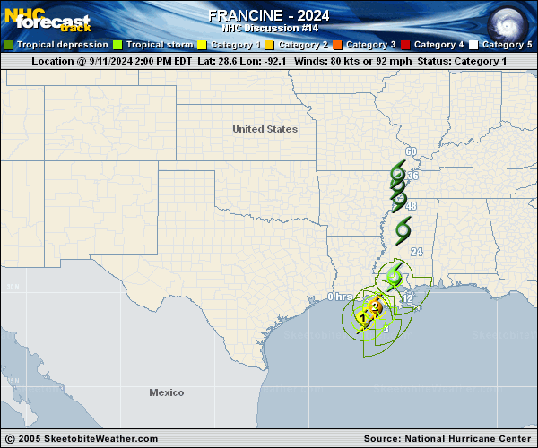
Copy of official data Tropical Storm Francine Discussion Number 14 NWS National Hurricane Center Miami FL AL062024 1000 PM CDT Wed Sep 11 2024 Francine made landfall in Terrebonne Parish in southern Louisiana around 5 pm CDT (2200 UTC) as a Category 2 hurricane. Maximum winds at landfall were estimated to be around 85 kt based on data collected by the Air Force Hurricane Hunters. Since then, Francine has been rapidly weakening, and the maximum winds are now estimated to be near 60 kt, making it a tropical storm. The convective pattern has become quite asymmetric with nearly all of the heavy rains confined to the north of the center. Some of the heaviest rainfall and tropical-storm-force winds are occurring in metropolitan New Orleans, where there have been gusts to near 60 kt. The storm continues to move northeastward at a relatively quick 14 kt. However, a slow down is expected as the system weakens and merges with a mid- to upper-level trough to its northwest, which could cause flooding over portions of the southern U.S. As Francine continues inland, the storm will spin down and likely become a tropical depression by late Thursday and a post-tropical cyclone Thursday night or early Friday. An experimental cone graphic that includes inland Hurricane and Tropical Storm Watches and Warnings in the U.S. is now available on the NHC website. Due to the time needed to compile the inland watch and warning information, the experimental cone graphic will not be available as quickly as the operational cone. Once it is available, the experimental cone graphic can be found from a red weblink above the operational cone graphic at https://www.nhc.noaa.gov/graphics_at1.shtml?cone#contents. Users are encouraged to take the experimental product survey found below the experimental cone. KEY MESSAGES: 1. There is a danger of life-threatening storm surge during the next several hours for portions of the Louisiana and Mississippi coastlines, where a Storm Surge Warning remains in effect. Residents in the warning area should continue to follow advice given by local officials. 2. Damaging winds are expected to continue in portions of southern Louisiana overnight. Remain in a safe location until conditions improve. 3. Francine is expected to bring heavy rainfall and the risk of considerable flash and urban flooding, along with river flooding, across southeastern Louisiana, Mississippi, far southern Alabama, and the Florida Panhandle through Thursday night. Flash and urban flooding is probable across the Lower Tennessee Valley and Lower Mississippi Valley into Friday morning. FORECAST POSITIONS AND MAX WINDS INIT 12/0300Z 30.2N 90.6W 60 KT 70 MPH...INLAND 12H 12/1200Z 32.0N 89.7W 40 KT 45 MPH...INLAND 24H 13/0000Z 34.4N 89.8W 30 KT 35 MPH...INLAND 36H 13/1200Z 35.4N 90.1W 25 KT 30 MPH...POST-TROP/EXTRATROP 48H 14/0000Z 35.9N 90.2W 25 KT 30 MPH...POST-TROP/EXTRATROP 60H 14/1200Z...DISSIPATED $$ Forecaster Cangialosi |