Official Discussion issued by the National Hurricane Center
Leslie (AL132024) DATA RELEASED: 10/5/2024 3:00:00 PM UTC
|
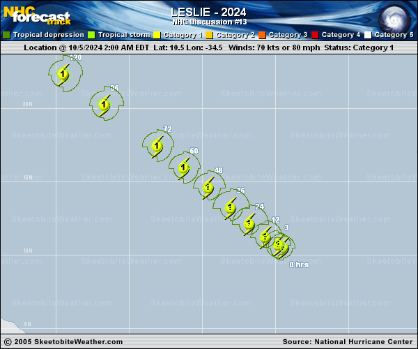
Copy of official data Hurricane Leslie Discussion Number 13 NWS National Hurricane Center Miami FL AL132024 1100 AM AST Sat Oct 05 2024 Deep convection continues to burst over the center of Leslie this morning. Some of the latest satellite images depict a little bit of shear starting to impact the system, with a sharper convective edge on the western side. Subjective and objective satellite intensity estimates range from 65 to 75 kt. Using a blend of these estimates, the initial intensity is held at 70 kt for this advisory. Leslie continues to move slowly west-northwestward (295/6 kt), steered by a mid-level subtropical ridge over the eastern Atlantic. The ridge will continue to steer Leslie the next several days with a turn more northwestward, with an increase in forward speed by the middle of the forecast period. The NHC track forecast is very close to the previous, and lies near the simple and corrected consensus aids. The intensity forecast continues to trend downward with Leslie. The system has about 12-24 hours left within a favorable environment where some slight additional strengthening may occur. By Sunday, increased shear, drier mid-level, and the track taking Leslie over Kirk's cold wake, this could cause some weakening after 24 hours. There is better agreement with the weakening trend, however they differ on how significantly and how quickly weakening will occur. Therefore, downward adjustments were made to the NHC intensity forecast and now has Leslie weakening below hurricane strength beyond 48 h. If trends continue further downward adjustments may be required in future advisories. FORECAST POSITIONS AND MAX WINDS INIT 05/1500Z 11.1N 35.4W 70 KT 80 MPH 12H 06/0000Z 11.7N 36.2W 75 KT 85 MPH 24H 06/1200Z 12.7N 37.4W 75 KT 85 MPH 36H 07/0000Z 13.8N 38.7W 70 KT 80 MPH 48H 07/1200Z 15.0N 40.3W 65 KT 75 MPH 60H 08/0000Z 16.4N 42.1W 60 KT 70 MPH 72H 08/1200Z 17.8N 44.0W 60 KT 70 MPH 96H 09/1200Z 20.4N 47.7W 55 KT 65 MPH 120H 10/1200Z 22.4N 50.4W 55 KT 65 MPH $$ Forecaster Kelly |