Official Discussion issued by the National Hurricane Center
Kirk (AL122024) DATA RELEASED: 10/2/2024 9:00:00 PM UTC
|
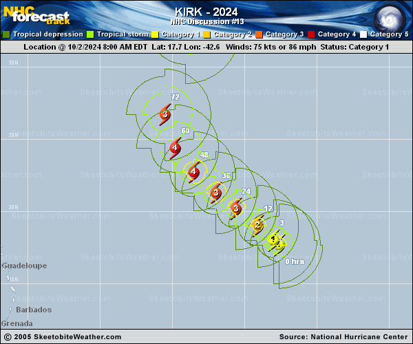
Copy of official data Hurricane Kirk Discussion Number 13 NWS National Hurricane Center Miami FL AL122024 500 PM AST Wed Oct 02 2024 This afternoon, Kirk has the appearance of an intensifying hurricane. While the eye still remains obscured on visible satellite imagery, an earlier AMSR2 microwave pass at 1604 UTC showed the inner-core continues to improve, with a notable cyan ring on the 37 GHz channel. This signal is often a harbinger of more substantial intensification. While the subjective Dvorak estimates remain unchanged from this morning, the improvement of the storm structure on microwave imagery suggests intensification has continued, and the initial intensity is set at 80 kt for this advisory. The hurricane has maintained its motion throughout the day, still northwestward at 310/10 kt. There is not a lot of new information to report about the track philosophy, with Kirk expected to round the western edge of the subtropical ridge that has been its primary steering mechanism over the last few days. This ridge is forecast to become eroded by a deep-layer trough approaching from the west, and Kirk will ultimately track in between these two features, beginning to accelerate as the tropical cyclone recurves into the higher latitudes. The track guidance remains in good agreement with lower-than-average spread on the forecast track, and the NHC track is very similar to the prior advisory and is quite close to both the ECMWF, GFS, and consensus aid track solutions. All systems appear go for Kirk to intensify significantly over the next couple of days, and the NHC intensity forecast shows the hurricane intensifying to a Category 4 hurricane in 48 h, in good agreement with the hurricane-regional model guidance. Thereafter, inner-core fluctuations plus increasing southwesterly shear from the upper-level trough to its west is expected to cause gradual weakening, as shown in the NHC forecast after that time. Kirk is also expected to continue growing in size through the forecast period. By the end of the forecast, Kirk should begin extratropical transition in the high-latitudes, likely to be completed just beyond day 5. FORECAST POSITIONS AND MAX WINDS INIT 02/2100Z 18.9N 44.0W 80 KT 90 MPH 12H 03/0600Z 19.9N 45.1W 90 KT 105 MPH 24H 03/1800Z 21.1N 46.6W 105 KT 120 MPH 36H 04/0600Z 22.4N 48.1W 110 KT 125 MPH 48H 04/1800Z 23.8N 49.5W 115 KT 130 MPH 60H 05/0600Z 25.7N 50.5W 110 KT 125 MPH 72H 05/1800Z 28.5N 50.6W 105 KT 120 MPH 96H 06/1800Z 35.1N 47.9W 90 KT 105 MPH 120H 07/1800Z 42.5N 38.0W 80 KT 90 MPH $$ Forecaster Papin |