Official Discussion issued by the National Hurricane Center
Joyce (AL112024) DATA RELEASED: 9/30/2024 3:00:00 PM UTC
|
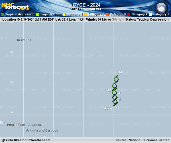
Copy of official data Tropical Depression Joyce Discussion Number 13 NWS National Hurricane Center Miami FL AL112024 1100 AM AST Mon Sep 30 2024 Joyce continues to struggle to remain a tropical depression, having a fully exposed low-level center displaced to the west of pulsing deep convection. This displacement is a result of strong southwesterly vertical wind shear ahead of a central Atlantic upper-level trough. With no recent surface observations or scatterometer wind data available, 30 kt will remain the initial intensity, reflecting the subjective Dvorak analysis from TAFB and SAB. The depression has meandered this morning, and the current motion estimate is an uncertain 360/2 kt. The official track forecast depicts a slow northward motion until Joyce fully dissipates in 48 h, similar to the previous track forecast. Continued shear coupled with persistent dry air should increasingly inhibit organized convection, leading to Joyce degenerating into a remnant low soon. The intensity forecast is similar to the previous one showing Joyce becoming a remnant low in 12 h with total dissipation in about 48 h. FORECAST POSITIONS AND MAX WINDS INIT 30/1500Z 22.4N 49.3W 30 KT 35 MPH 12H 01/0000Z 23.1N 49.4W 30 KT 35 MPH...POST-TROP/REMNT LOW 24H 01/1200Z 24.1N 49.5W 30 KT 35 MPH...POST-TROP/REMNT LOW 36H 02/0000Z 25.3N 49.5W 25 KT 30 MPH...POST-TROP/REMNT LOW 48H 02/1200Z 27.0N 49.1W 20 KT 25 MPH...POST-TROP/REMNT LOW 60H 03/0000Z...DISSIPATED $$ Forecaster Konarik/Papin |