Official Discussion issued by the National Hurricane Center
Isaac (AL102024) DATA RELEASED: 9/29/2024 3:00:00 AM UTC
|
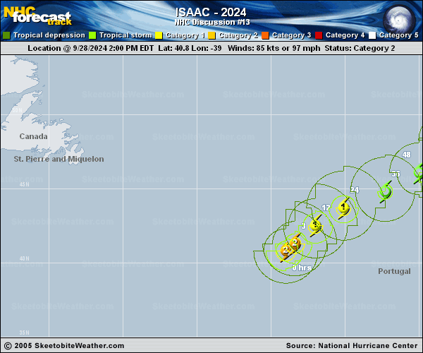
Copy of official data Hurricane Isaac Discussion Number 13 NWS National Hurricane Center Miami FL AL102024 300 AM GMT Sun Sep 29 2024 Isaac continues to weaken tonight. Southwesterly shear and intrusions of drier mid-level air have eroded convection over the southern portion of the hurricane, and there is no longer a coherent eye feature in satellite images. A partial scatterometer pass shows a frontal zone in close proximity to the east of Isaac, signaling extratropical transition could begin soon. A blend of the TAFB and SAB Dvorak Current Intensity estimates with objective UW-CIMSS estimates supports lowering the intensity to 70 kt. As Isaac moves deeper into the mid-latitudes, it will cross even cooler waters and encounter increasing deep-layer shear. Thus, continued weakening is likely, and Isaac is expected to lose tropical characteristics soon and complete extratropical transition by Monday while becoming entangled with a nearby frontal system. The updated NHC forecast shows a faster rate of weakening in the near term. The wind radii of Isaac are likely to become increasingly asymmetric as the cyclone takes on frontal characteristics. Isaac is moving northeastward at about 13 kt. This general motion should continue for the next couple of days while Isaac remains embedded in deep-layer southwesterly flow. The storm is forecast to turn more north-northeastward by midweek as an upper-level trough digs to the west of Isaac. There is more track spread in the guidance related to this interaction, and the extratropical portion of the NHC track forecast was adjusted slightly to the right of the previous prediction, following the latest multi-model consensus trends. FORECAST POSITIONS AND MAX WINDS INIT 29/0300Z 42.1N 37.6W 70 KT 80 MPH 12H 29/1200Z 43.1N 36.3W 65 KT 75 MPH 24H 30/0000Z 44.2N 33.7W 55 KT 65 MPH...POST-TROPICAL 36H 30/1200Z 45.4N 30.6W 50 KT 60 MPH...POST-TROP/EXTRATROP 48H 01/0000Z 47.1N 28.3W 45 KT 50 MPH...POST-TROP/EXTRATROP 60H 01/1200Z 49.2N 27.1W 40 KT 45 MPH...POST-TROP/EXTRATROP 72H 02/0000Z 51.1N 26.3W 40 KT 45 MPH...POST-TROP/EXTRATROP 96H 03/0000Z 55.0N 24.4W 35 KT 40 MPH...POST-TROP/EXTRATROP 120H 04/0000Z 58.0N 20.0W 35 KT 40 MPH...POST-TROP/EXTRATROP $$ Forecaster Reinhart |