Official Discussion issued by the National Hurricane Center
Ernesto (AL052024) DATA RELEASED: 8/14/2024 9:00:00 PM UTC
|
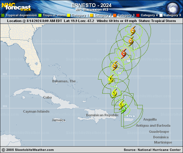
Copy of official data Hurricane Ernesto Discussion Number 13 NWS National Hurricane Center Miami FL AL052024 500 PM AST Wed Aug 14 2024 Visible satellite imagery shows that Ernesto's cloud field is gradually expanding, and there have been hints of an eye potentially forming in the Central Dense Overcast. The Air Force Reserve mission from a few hours ago found that the central pressure had fallen to 989 mb, but there were no indications that the maximum winds were any higher than 65 kt. The initial intensity is therefore held at that level, which is also supported by the latest satellite intensity estimates. Ernesto is still moving northwestward but continues to turn to the right, and the initial motion is 325/14 kt. A turn toward the north-northwest and north is expected tonight and on Thursday as the hurricane moves through a break in the subtropical ridge, but the trough causing this break is forecast to leave Ernesto behind later in the week. The result is that Ernesto is likely to slow down while it passes very near Bermuda Friday night and Saturday. Thereafter, a second trough approaching from the west should cause Ernesto to accelerate toward the northeast, near or just south of Atlantic Canada. The track models are in very good agreement on this scenario, but there is a bit of east-to-west spread after 48 hours. The new NHC track forecast has been nudged eastward after 48 hours to be close to the multi-model consensus aids, although at this time it is too soon to know exactly how close Ernesto's center will move to Bermuda this weekend. An environment of warm ocean waters (around 29 degrees Celsius) and low to moderate shear should allow Ernesto to strengthen gradually during the next few days. Most of the intensity models indicate that the hurricane should peak in intensity in about 48 hours. At that time, the official forecast shows a peak of 100 kt--major hurricane--which is near the top end of the guidance and close to the HAFS-B, COAMPS-TC, and HCCA models. A weakening trend should begin after 48 hours due to moderate shear and a drier, more stable atmosphere, but the weakening is likely to be gradual. As a result, the official forecast keeps Ernesto as a hurricane throughout the 5-day forecast period. Key Messages: 1. Hurricane conditions are possible on Bermuda on Saturday, with tropical storm conditions possible by Friday afternoon. Rainfall associated with Ernesto may begin to affect Bermuda as early as Thursday and result in flash flooding across Bermuda later in the week and this weekend. 2. Heavy rainfall will be diminishing across Puerto Rico into the Virgin Islands this evening. Locally considerable flash flooding and mudslides will continue through tonight over the Virgin Islands and into portions of Puerto Rico. 3. Even though Ernesto is forecast to remain well offshore the U.S. East Coast, swells generated by the storm are expected to reach the area late this week and into the weekend. Beach goers should be aware of a significant risk of life-threatening surf and rip currents, and stay out of the water if advised by lifeguards. Surf and rip currents are also possible on the Virgin Islands, Puerto Rico, the Dominican Republic, the Turks and Caicos, and the Bahamas during the next few days. FORECAST POSITIONS AND MAX WINDS INIT 14/2100Z 21.7N 68.3W 65 KT 75 MPH 12H 15/0600Z 23.5N 69.0W 75 KT 85 MPH 24H 15/1800Z 25.7N 69.0W 85 KT 100 MPH 36H 16/0600Z 27.7N 68.0W 95 KT 110 MPH 48H 16/1800Z 29.5N 66.6W 100 KT 115 MPH 60H 17/0600Z 31.3N 65.7W 95 KT 110 MPH 72H 17/1800Z 32.9N 65.4W 90 KT 105 MPH 96H 18/1800Z 37.0N 64.2W 85 KT 100 MPH 120H 19/1800Z 43.4N 58.2W 80 KT 90 MPH $$ Forecaster Berg |