Official Discussion issued by the National Hurricane Center
Leslie (AL132024) DATA RELEASED: 10/5/2024 9:00:00 AM UTC
|
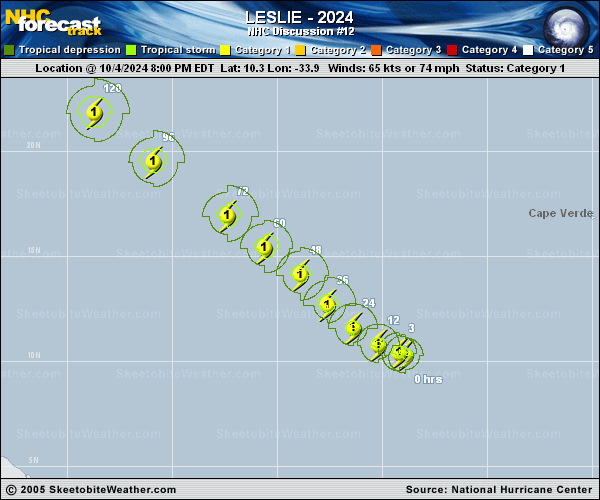
Copy of official data Hurricane Leslie Discussion Number 12 NWS National Hurricane Center Miami FL AL132024 500 AM AST Sat Oct 05 2024 A 0552 UTC SSMIS microwave pass showed that Leslie still has a well-defined mid-level eye, and deep convection continues to burst over the center. Dvorak estimates from TAFB and SAB are both T4.0/65 kt, while objective numbers are overall a bit higher than that. Therefore, Leslie's intensity is now estimated to be 70 kt. Leslie continues to move slowly west-northwestward (290/6 kt), with the cyclone still located along the southern periphery of the subtropical ridge. The ridge is expected to remain entrenched and strengthen over the eastern Atlantic during the next several days, which should cause Leslie to move northwestward and accelerate a bit by Tuesday and Wednesday. The NHC forecast is close to a blend of the TVCA and HCCA consensus aids, and nearly lies on top of the previous prediction. The intensity forecast is the most challenging part of this advisory. Deep-layer shear is relatively low at the moment and should remain so for the next 24 hours or so. This is the period where the NHC forecast shows additional strengthening, and is close to the statistical-dynamical models near the top end of the guidance. Increased shear, combined with Leslie potentially moving over Kirk's cold wake, could cause some weakening after 24 hours. All of the intensity models support this scenario, however they differ significantly in how much weakening will occur. The NHC forecast continues to show Leslie maintaining hurricane status through day 5, mainly following the SHIPS model. However, the IVCN and HCCA consensus aids, as well as several of the hurricane regional models, suggest that Leslie could weaken below hurricane intensity by 48 hours. Downward adjustments to the intensity forecast may be required in future advisories if this trend continues. FORECAST POSITIONS AND MAX WINDS INIT 05/0900Z 10.7N 34.8W 70 KT 80 MPH 12H 05/1800Z 11.2N 35.7W 75 KT 85 MPH 24H 06/0600Z 12.1N 36.8W 80 KT 90 MPH 36H 06/1800Z 13.2N 38.1W 75 KT 85 MPH 48H 07/0600Z 14.6N 39.6W 70 KT 80 MPH 60H 07/1800Z 15.9N 41.3W 70 KT 80 MPH 72H 08/0600Z 17.4N 43.1W 70 KT 80 MPH 96H 09/0600Z 20.2N 46.7W 65 KT 75 MPH 120H 10/0600Z 22.3N 49.5W 65 KT 75 MPH $$ Forecaster Berg |