Official Discussion issued by the National Hurricane Center
Kirk (AL122024) DATA RELEASED: 10/2/2024 3:00:00 PM UTC
|
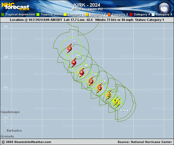
Copy of official data Hurricane Kirk Discussion Number 12 NWS National Hurricane Center Miami FL AL122024 1100 AM AST Wed Oct 02 2024 Kirk continues to intensify this morning. On geostationary satellite imagery convective bands continue to rotate around the eye seen earlier in microwave imagery, although this feature hasn't shown up yet on visible imagery. The subjective Dvorak estimates were a consensus T4.5/77 kt, and blending these estimates with somewhat lower objective intensity estimates, the intensity has been raised to 75 kt this advisory. Kirk continues moving northwestward, or 305/10 kt. A gradual slowdown at a similar heading is expected over the next day or two as the hurricane remains steered by a subtropical ridge centered to its northeast. At the end of the week, Kirk will find itself between an increasingly eroded ridge to its east, and a digging upper-level trough to its west, and it is likely Kirk will be steered between these features, recurving northward, and then north-northeastward by the end of the forecast period. The latest NHC track forecast is very similar to the prior one, especially over the next several days, but is a little further northwest thereafter, blending the prior track forecast to the consensus aids TCVA and HCCA, though in general the track spread among the track guidance remains relatively low. Kirk appears poised to intensify quite a bit in the short-term now that shear has decreased as the hurricane remains over very warm ocean waters and plenty of deep-layer moisture. These favorable conditions should promote notable strengthening, and the latest NHC intensity forecast now shows Kirk becoming a major hurricane in 24 h, and peaking as a 115 kt Category 4 hurricane in 48 h. Thereafter, southwesterly shear from the upper-level trough to its west could begin to increase, leading to a gradual weakening trend. The latest intensity forecast is a little higher than earlier, owing to somewhat higher intensity guidance aids this cycle, but still remains lower than some of the more bullish guidance (HAFS-B) but is roughly in line with HCCA this cycle. Kirk is also expected to continue growing in size with a larger than average radius of both tropical storm and hurricane-force wind radii as it recurves into the open Atlantic Ocean. FORECAST POSITIONS AND MAX WINDS INIT 02/1500Z 18.0N 43.0W 75 KT 85 MPH 12H 03/0000Z 19.0N 44.1W 85 KT 100 MPH 24H 03/1200Z 20.2N 45.6W 100 KT 115 MPH 36H 04/0000Z 21.3N 47.0W 110 KT 125 MPH 48H 04/1200Z 22.7N 48.5W 115 KT 130 MPH 60H 05/0000Z 24.4N 49.8W 115 KT 130 MPH 72H 05/1200Z 26.7N 50.5W 110 KT 125 MPH 96H 06/1200Z 32.7N 49.1W 100 KT 115 MPH 120H 07/1200Z 39.6N 42.0W 80 KT 90 MPH $$ Forecaster Papin |