Official Discussion issued by the National Hurricane Center
Gordon (AL072024) DATA RELEASED: 9/14/2024 9:00:00 AM UTC
|
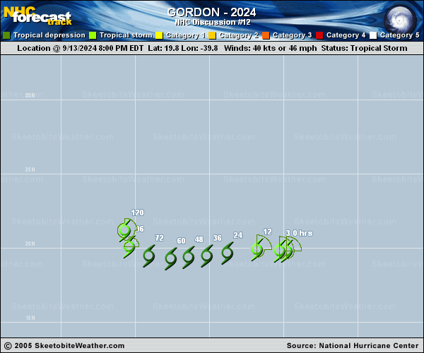
Copy of official data Tropical Storm Gordon Discussion Number 12 NWS National Hurricane Center Miami FL AL072024 500 AM AST Sat Sep 14 2024 The center of Gordon appears to be racing out ahead of the deep convective mass to its east in recent proxy-visible satellite images. This appearance is consistent with moderate deep-layer westerly shear over the cyclone as indicated by model soundings. Earlier scatterometer data showed the extent of tropical-storm-force winds was about 100 n mi in the northern semicircle of the storm. The circulation on the southwest side of the storm was not as well defined, with relatively weak winds and signs of elongation. A blend of the latest subjective TAFB/SAB Dvorak estimates and objective estimates from UW-CIMSS support an initial intensity of 40 kt, which is also consistent with the scatterometer winds. The sheared storm is moving into a drier and more stable air mass, which is likely to induce some weakening during the next couple of days. In fact, some models continue to show the possibility of Gordon losing organized convection and degenerating to a remnant low. The official NHC forecast brings Gordon to a depression in 24 h but maintains it as a tropical cyclone for now. Environmental conditions should become less hostile by the middle of next week, and the NHC forecast indicates some re-strengthening could occur during that time. This part of the forecast remains conservative, as there are still several dynamical models that show little, if any, re-intensification later next week. Gordon appears to be moving west-northwestward (285/8 kt), but a gradual turn toward the west and west-southwest is forecast over the next couple of days, in good agreement with the latest track guidance. Track forecast confidence decreases at days 3-5, where the motion appears more sensitive to whether or not Gordon restrengthens. A weakness in the mid-level subtropical ridge is forecast to develop, which would allow the system to gain some latitude if its vertical depth matches that steering level. However, a shallower system could continue moving slowly westward within the low-level flow. The updated NHC forecast shows a more gradual turn toward the northwest and north at days 3-5, in best agreement with the TVCA simple consensus aid. FORECAST POSITIONS AND MAX WINDS INIT 14/0900Z 20.1N 40.9W 40 KT 45 MPH 12H 14/1800Z 20.0N 42.4W 35 KT 40 MPH 24H 15/0600Z 19.9N 44.1W 30 KT 35 MPH 36H 15/1800Z 19.7N 45.6W 30 KT 35 MPH 48H 16/0600Z 19.5N 46.9W 30 KT 35 MPH 60H 16/1800Z 19.3N 48.4W 30 KT 35 MPH 72H 17/0600Z 19.2N 49.7W 30 KT 35 MPH 96H 18/0600Z 19.5N 51.0W 35 KT 40 MPH 120H 19/0600Z 21.0N 51.5W 40 KT 45 MPH $$ Forecaster Reinhart |