Official Discussion issued by the National Hurricane Center
Milton (AL142024) DATA RELEASED: 10/7/2024 4:00:00 PM UTC
|
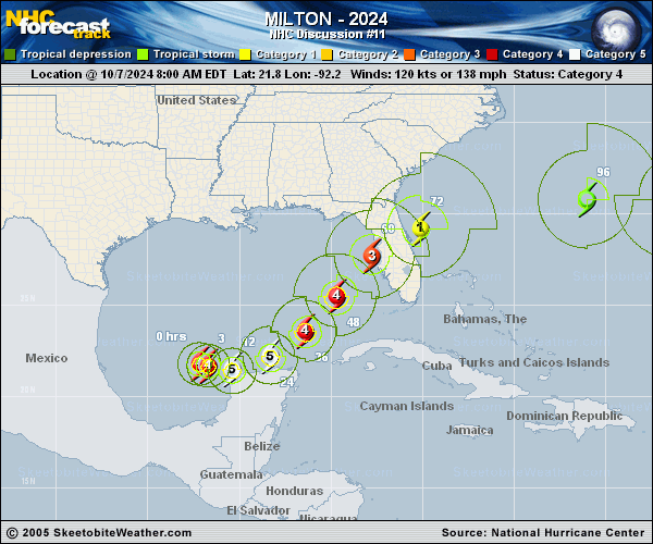
Copy of official data Hurricane Milton Discussion Number 11 NWS National Hurricane Center Miami FL AL142024 400 PM CDT Mon Oct 07 2024 Satellite images indicate that Milton is quite a powerful hurricane. The small eye has become even more distinct than earlier today, and radar data from Sabancuy show a small, closed eye with a very strong eyewall presentation. On the last fix before the plane departed a few hours ago, the Air Force Hurricane Hunter crew reported that the pressure had fallen to 911 mb, which is 77 mb lower than yesterday at the same time, with other data to support 150 kt. Since the satellite imagery continues to show intensification, the initial wind speed is set to 155 kt, and a pair of Hurricane Hunters should be in the area this evening for more information. The hurricane is moving eastward at about 9 kt. Milton should move close to the northern portion of Yucatan Peninsula tonight and early Tuesday ahead of a mid-level trough dropping into the northwestern Gulf of Mexico. This feature should then cause Milton to move east-northeastward to northeastward at a faster forward speed later on Tuesday and Wednesday. Little change was made to the previous forecast, with the latest model guidance very close to the previous forecast cycle, and this forecast remains close to a consensus of the latest GFS, ECMWF and regional hurricane models. Note that this track is closer to the model fields rather than the model trackers which appear to be too far south. Milton could strengthen even more tonight with light shear and very warm waters providing a conducive environment. However, radar data indicate that Milton could be at the beginning of an eyewall replacement cycle, with some signs of a moat and a partial outer eyewall. The evolution will likely cause the system to gradually weaken on Tuesday but grow larger. On Wednesday, Milton is expected to encounter a less favorable environment with strong shear and dry air entrainment, with further weakening forecast. Regardless, the system is expected to be a large and powerful hurricane at landfall in Florida, with life-threatening hazards at the coastline and well inland. Residents in Florida should closely follow the orders from their local emergency management officials, as Milton has the potential to be one of the most destructive hurricanes on record for west-central Florida. Key Messages: 1. Damaging hurricane-force winds and a life-threatening storm surge with destructive waves are expected across portions of the northern coast of the Yucatan Peninsula through tonight. 2. Milton is expected to grow in size and remain an extremely dangerous hurricane when it approaches the west coast of Florida on Wednesday. A large area of destructive storm surge will occur along parts of the west coast of Florida on Wednesday. This is an extremely life-threatening situation and residents in those areas should follow advice given by local officials and evacuate immediately if told to do so. 3. Potentially devastating hurricane-force winds are expected along portions of the west coast of Florida where a Hurricane Warning is in effect. Milton is forecast to remain a hurricane as it crosses the Florida Peninsula and life-threatening hurricane-force winds, especially in gusts, are expected to spread inland across a portion of the entire Florida Peninsula. Preparations to protect life and property in the warning areas should be complete by Tuesday night since tropical storm conditions are expected to begin within this area early Wednesday. 4. Areas of heavy rainfall will impact portions of Florida today well ahead of Milton, with heavy rainfall more directly related to the system expected later on Tuesday through Wednesday night. This rainfall will bring the risk of considerable flash, urban, and areal flooding, along with the potential for moderate to major river flooding. FORECAST POSITIONS AND MAX WINDS INIT 07/2100Z 21.8N 90.8W 155 KT 180 MPH 12H 08/0600Z 21.9N 89.4W 160 KT 185 MPH 24H 08/1800Z 22.7N 87.4W 150 KT 175 MPH 36H 09/0600Z 24.2N 85.6W 140 KT 160 MPH 48H 09/1800Z 26.1N 84.0W 125 KT 145 MPH 60H 10/0600Z 27.9N 82.6W 110 KT 125 MPH...INLAND 72H 10/1800Z 29.2N 79.5W 75 KT 85 MPH...OVER WATER 96H 11/1800Z 30.5N 71.0W 55 KT 65 MPH...POST-TROP/EXTRATROP 120H 12/1800Z 31.0N 65.0W 40 KT 45 MPH...POST-TROP/EXTRATROP $$ Forecaster Blake |