Official Discussion issued by the National Hurricane Center
Isaac (AL102024) DATA RELEASED: 9/28/2024 3:00:00 PM UTC
|
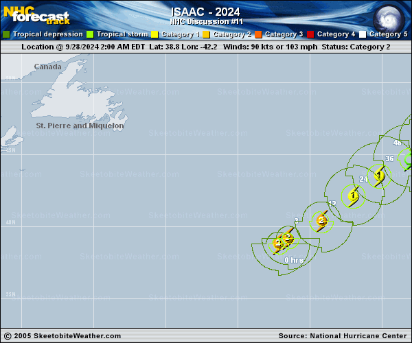
Copy of official data Hurricane Isaac Discussion Number 11 NWS National Hurricane Center Miami FL AL102024 300 PM GMT Sat Sep 28 2024 Isaac's strengthening trend from the past day or so appears to have leveled off. Isaac still has a clear eye and a relatively symmetric appearance, although some dry air entrainment is evident coming in from the southwest. Intensity estimates range from 77 to 93 kt, and initial intensity has been held at 90 kt, in agreement with TAFB's Dvorak classification of 5.0. The wind radii have been modified to reflect values from 1245 UTC ASCAT-B pass. Isaac is already over relatively cool water and will reach progressively lower SSTs in the coming day or two, all while encountering increasingly hostile shear. Thus, Isaac's intensity has most likely peaked, and gradual weakening today is forecast to accelerate through the weekend. This weakening will coincide with an extratropical transition, which based on global models, will complete in about 48 hours. The NHC intensity forecast remains unchanged from the previous forecast and is in close agreement with consensus aids through the forecast period. Isaac is moving east-northeastward, 060/17 kt. Steering flow should decrease as Isaac passes in the vicinity of a mid- to upper- level ridge over the next day or so, which should lead to slower forward motion through the remainder of its warm-core existence. As Isaac becomes extratropical, it should turn more northerly as a shortwave trough digs to the west of the cyclone. The official track forecast remains unchanged through 48 hours but has again trended to the right of the previous forecast beyond 48 hours to adjust closer to consensus models. FORECAST POSITIONS AND MAX WINDS INIT 28/1500Z 40.2N 39.7W 90 KT 105 MPH 12H 29/0000Z 41.4N 37.8W 85 KT 100 MPH 24H 29/1200Z 42.9N 36.1W 75 KT 85 MPH 36H 30/0000Z 44.0N 33.9W 65 KT 75 MPH 48H 30/1200Z 45.4N 31.5W 55 KT 65 MPH...POST-TROPICAL 60H 01/0000Z 47.1N 29.4W 45 KT 50 MPH...POST-TROPICAL 72H 01/1200Z 49.6N 28.7W 45 KT 50 MPH...POST-TROP/EXTRATROP 96H 02/1200Z 53.5N 28.1W 40 KT 45 MPH...POST-TROP/EXTRATROP 120H 03/1200Z 56.6N 25.0W 35 KT 40 MPH...POST-TROP/EXTRATROP $$ Forecaster Konarik/Cangialosi |