Official Discussion issued by the National Hurricane Center
Gordon (AL072024) DATA RELEASED: 9/14/2024 3:00:00 AM UTC
|
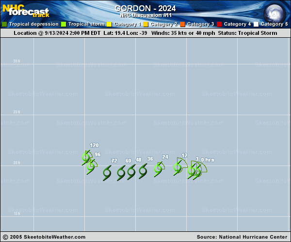
Copy of official data Tropical Storm Gordon Discussion Number 11 NWS National Hurricane Center Miami FL AL072024 1100 PM AST Fri Sep 13 2024 A 13/2045 UTC CSA RADARSAT Constellation Mission VH polarization image indicated that Gordon's surface center was farther east than previously indicated. Subsequently, the surface center has become more obscured while the convective mass has expanded somewhat over the western portion of the cyclone. A blend of the subjective Dvorak satellite intensity estimates from TAFB and SAB yields an intensity of 40 kt for this advisory. Although the statistical SHIPS intensity guidance shows the westerly shear gradually diminishing through the period, the dry, stable thermodynamic surrounding environment is expected to be the primary inhibiting parameter. Gordon could degenerate to a remnant low around mid-period, although not shown explicitly in the NHC forecast. Beyond day 3, the official forecast shows gradual re-strengthening while atmospheric conditions become less hostile. The NHC intensity forecast is similar to the previous advisory and based on the IVCN intensity consensus and below the Decay SHIPS statistical guidance. Gordon's initial motion is estimated to be westward or 280/8 kt and is steered by a low- to mid-tropospheric ridge extending west-southwestward from high pressure over the Azores. The cyclone should continue slowly toward the west to west-southwest during the next 72 hours. Afterward, a break in the subtropical ridge over the central Atlantic is forecast in response to an amplifying mid- to upper-level trough. As Gordon approaches this growing weakness in the ridge, the cyclone should turn toward the northwest and north. This forecast track scenario, however, assumes that the cyclone strengthens toward the end of the period. Only a slight adjustment to the left of the previous forecast beyond day 3 was made to lie closer to the TVCN consensus aid. FORECAST POSITIONS AND MAX WINDS INIT 14/0300Z 19.8N 40.3W 40 KT 45 MPH 12H 14/1200Z 19.9N 41.8W 40 KT 45 MPH 24H 15/0000Z 19.7N 43.8W 30 KT 35 MPH 36H 15/1200Z 19.5N 45.2W 30 KT 35 MPH 48H 16/0000Z 19.4N 46.4W 30 KT 35 MPH 60H 16/1200Z 19.3N 47.6W 30 KT 35 MPH 72H 17/0000Z 19.5N 49.1W 30 KT 35 MPH 96H 18/0000Z 20.1N 50.4W 35 KT 40 MPH 120H 19/0000Z 21.2N 50.7W 40 KT 45 MPH $$ Forecaster Roberts |