Official Discussion issued by the National Hurricane Center
Milton (AL142024) DATA RELEASED: 10/7/2024 10:00:00 AM UTC
|
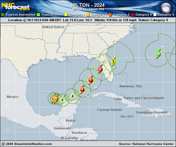
Copy of official data Hurricane Milton Discussion Number 10 NWS National Hurricane Center Miami FL AL142024 1000 AM CDT Mon Oct 07 2024 Milton's remarkable rapid intensification is continuing. Satellite images show a small eye within the very cold central cloud cover, and the eye is becoming better defined. Data from the Mexican radar at Sabancuy show a small, closed eye with an intense eyewall presentation. The Hurricane Hunter aircraft earlier reported a peak flight-level wind of 146 kt, and dropsonde data show that the pressure has fallen to around 933 mb, which is down about 22 mb in 4 hours. The initial wind speed is set to 135 kt, which is an 80-kt increase in 24 hours (only eclipsed by Wilma 2005 and Felix 2007 in our records). The hurricane is still moving east-southeastward, now about 8 kt. Global models continue to insist that Milton will turn eastward soon as the frontal low pressure area over the northeastern Gulf of Mexico departs. The new forecast near Mexico is about the same as the previous one, but is close enough to bring hurricane-force winds to the northern portion of Yucatan Peninsula. Later, a new mid-level trough dropping into the northwestern Gulf of Mexico should then cause Milton to move east-northeastward to northeastward at a faster forward speed. The latest model fields are a bit left of the previous runs, and the official NHC track forecast is shifted to the north. This forecast is close to a consensus of the latest GFS, ECMWF and regional hurricane models. Note that this track is closer to the model fields rather than the model trackers which appear to be too far south. Milton is likely to become a category 5 hurricane later today with light shear and very warm waters in its path. By tomorrow, its intensity should be dictated by any eyewall replacement cycles, which will likely cause the system to gradually weaken but grow larger. After 36 h, Milton is expected to encounter a much less favorable environment with strong shear and dry air entrainment. Therefore, some weakening is anticipated before the hurricane reaches the Florida Gulf coast. However, the system is still likely to be a large and powerful hurricane at landfall in Florida, with life-threatening hazards at the coastline and well inland. After landfall, Milton should weaken and start extratropical transition, which should be complete by 96 h. Key Messages: 1. Damaging hurricane-force winds are expected across portions of the northern coast of the Yucatan Peninsula. A life-threatening storm surge with damaging waves is also likely along portions of the northern coast of the Yucatan Peninsula. 2. There is an increasing risk of life-threatening storm surge and damaging winds for portions of the west coast of the Florida Peninsula beginning Tuesday night or early Wednesday. Storm Surge and Hurricane Watches are now in effect for portions of the west coast of the Florida Peninsula and residents in that area should follow any advice given by local officials and evacuate if told to do so. 3. Areas of heavy rainfall will impact portions of Florida today well ahead of Milton, with heavy rainfall more directly related to the system expected later on Tuesday through Wednesday night. This rainfall will bring the risk of considerable flash, urban, and areal flooding, along with the potential for moderate to major river flooding. FORECAST POSITIONS AND MAX WINDS INIT 07/1500Z 21.7N 91.7W 135 KT 155 MPH 12H 08/0000Z 21.5N 90.4W 145 KT 165 MPH 24H 08/1200Z 22.2N 88.3W 140 KT 160 MPH 36H 09/0000Z 23.6N 86.4W 135 KT 155 MPH 48H 09/1200Z 25.5N 84.7W 125 KT 145 MPH 60H 10/0000Z 27.7N 82.8W 110 KT 125 MPH 72H 10/1200Z 29.2N 80.1W 80 KT 90 MPH 96H 11/1200Z 30.8N 71.0W 55 KT 65 MPH...POST-TROP/EXTRATROP 120H 12/1200Z 31.0N 66.0W 45 KT 50 MPH...POST-TROP/EXTRATROP $$ Forecaster Blake |