Official Discussion issued by the National Hurricane Center
Leslie (AL132024) DATA RELEASED: 10/4/2024 9:00:00 PM UTC
|
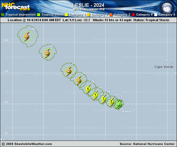
Copy of official data Tropical Storm Leslie Discussion Number 10 NWS National Hurricane Center Miami FL AL132024 500 PM AST Fri Oct 04 2024 The convective structure of Leslie has become better organized this afternoon with a more symmetrical convective shield. There have not been any helpful microwave or scatterometer passes the last several hours to help evaluate the structure further. The latest subjective Dvorak satellite intensity estimates were T/3.5 and T/4.0, from TAFB and SAB respectively. Using a blend of these estimates, the initial intensity is set to 60 kt for this advisory. Leslie is moving slowly west-northwestward at 290/6 kt, and this motion is expected to continue as the storm rounds the subtropical ridge anchored over the east Atlantic. Leslie should continue west-northwestward then turn more northwestward by the end of the weekend with a slight increase in forward speed through the end of the forecast period. The track guidance is fairly well clustered and the NHC track lies near the consensus aids. The intensity forecast has become a little more uncertain with varying model solutions the last few model cycles, especially with the peak intensity and potential weakening towards the middle to end of the period. Northeasterly shear from Kirk has started to weaken over the system this afternoon, and that has likely aided the improved convective pattern. Leslie will be within a favorable atmospheric and oceanic environment for steady strengthening over the next 2 days or so. Beyond that time models begin to plateau the strengthening or start a weakening trend, as Leslie encounters some westerly shear and a drier air mass. There is a notable difference between the GFS and ECMWF in how hostile the environment will be by five days, with the ECMWF showing more shear, a much drier air mass, and a much weaker Leslie. One other issue is that the forecast track is expected to take Leslie over the cold wake left behind from Hurricane Kirk. Given the lowering intensity guidance and varying model solutions, the NHC intensity forecast has been adjusted downward, but still lies at the higher end of the guidance envelope. Additional adjustments to the intensity forecast may be needed on later advisories. FORECAST POSITIONS AND MAX WINDS INIT 04/2100Z 10.3N 33.6W 60 KT 70 MPH 12H 05/0600Z 10.7N 34.6W 70 KT 80 MPH 24H 05/1800Z 11.2N 35.9W 75 KT 85 MPH 36H 06/0600Z 12.2N 37.1W 80 KT 90 MPH 48H 06/1800Z 13.5N 38.3W 80 KT 90 MPH 60H 07/0600Z 14.9N 39.8W 80 KT 90 MPH 72H 07/1800Z 16.3N 41.6W 75 KT 85 MPH 96H 08/1800Z 19.0N 45.0W 75 KT 85 MPH 120H 09/1800Z 21.5N 48.2W 70 KT 80 MPH $$ Forecaster Kelly |