Official Discussion issued by the National Hurricane Center
Isaac (AL102024) DATA RELEASED: 9/28/2024 9:00:00 AM UTC
|
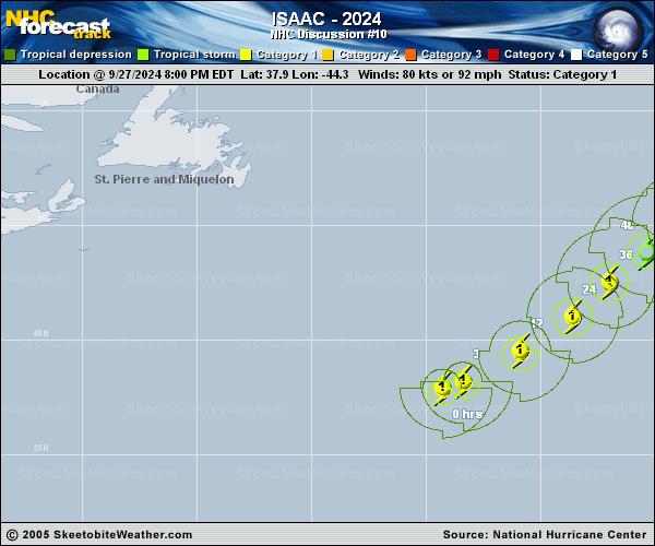
Copy of official data Hurricane Isaac Discussion Number 10 NWS National Hurricane Center Miami FL AL102024 900 AM GMT Sat Sep 28 2024 Isaac has continued to strengthen this morning. The satellite presentation consists of a 20 nm (WMG 8C) clear eye and an impressive curve band in the north side of the cyclone beneath the upper diffluent westerlies. The initial intensity is bumped up to 90 kt for this advisory and is based on a UW-CIMSS SATCON analysis of 93 kt and the Dvorak intensity estimates for TAFB and SAB. Some fluctuations in strength are possible during the day, after which Isaac will be traversing cooler oceanic surface temperatures and experiencing increasing deep-layer shear. Subsequently, gradual weakening is forecast, and the cyclone is expected to lose its deep core convection and become a post-tropical cyclone in 48 hrs. After that time, the global model fields and the FSU Cyclone Phase Evolution forecast show Isaac transitioning from a symmetric warm-core system to an asymmetric cold-core, more frontal thermal structure. The NHC intensity forecast is similar to the consensus aids and shows Isaac completing its extratropical cyclone transition by Tuesday. Isaac has turned toward the northeast, or 055/17 kt, in response to a mid-latitude shortwave ridge temporarily building to the north of the cyclone. By early next week, as Isaac loses its tropical characteristics and completes an extratropical transition, the cyclone should turn toward the north-northeast while a major shortwave trough approaches from the northwest over the central Atlantic. The official track forecast is adjusted a little to the right of the previous forecast beyond 48 hrs to agree more with the TVCA and HCCA consensus models. FORECAST POSITIONS AND MAX WINDS INIT 28/0900Z 39.3N 41.3W 90 KT 105 MPH 12H 28/1800Z 40.4N 39.2W 85 KT 100 MPH 24H 29/0600Z 42.1N 37.0W 75 KT 85 MPH 36H 29/1800Z 43.5N 35.2W 65 KT 75 MPH 48H 30/0600Z 44.6N 33.1W 55 KT 65 MPH...POST-TROPICAL 60H 30/1800Z 46.0N 31.5W 50 KT 60 MPH...POST-TROP/EXTRATROP 72H 01/0600Z 48.0N 30.4W 45 KT 50 MPH...POST-TROP/EXTRATROP 96H 02/0600Z 52.5N 30.0W 40 KT 45 MPH...POST-TROP/EXTRATROP 120H 03/0600Z 55.7N 28.6W 35 KT 40 MPH...POST-TROP/EXTRATROP $$ Forecaster Roberts |