Official Discussion issued by the National Hurricane Center
Ernesto (AL052024) DATA RELEASED: 8/14/2024 3:00:00 AM UTC
|
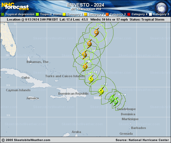
Copy of official data Tropical Storm Ernesto Discussion Number 10 NWS National Hurricane Center Miami FL AL052024 1100 PM AST Tue Aug 13 2024 Aircraft data, surface observations, and NWS radar images indicate Ernesto passed over the Virgin Islands around 00 UTC this evening. The tropical cyclone remains asymmetric, as NOAA Tail Doppler Radar data show the strongest winds and heaviest rainfall are generally confined to the northern and eastern semicircles of the storm. Data from the NOAA and Air Force Hurricane Hunters indicate the central pressure of Ernesto has fallen to around 998-999 mb, and an earlier aircraft pass through the eastern part of the storm found peak 700-mb flight-level winds of 60 kt. Based on these data, the initial intensity is set at 55 kt, which matches the latest Dvorak current intensity estimates from TAFB and SAB. The latest aircraft fixes and radar data show Ernesto has turned northwestward (305/15 kt). Overnight, Ernesto will move away from the Virgin Islands and pass to the northeast and north of Puerto Rico. Then, Ernesto is expected to move northwestward to northward during the next couple of days toward a break in the subtropical ridge. By late week, the influence of a deep-layer trough over the western Atlantic should cause Ernesto to turn north-northeastward, although the cyclone is forecast to slow down a bit after the trough passes to its north. There are no notable changes to the NHC track forecast, with Ernesto forecast to make its closest approach to Bermuda Friday night into Saturday. The radar structure of Ernesto indicates it has not yet solidified an inner core. However, once this occurs, the atmospheric and oceanic conditions appear conducive for significant strengthening over the next few days. Most of the hurricane regional models and statistical guidance show Ernesto becoming a major hurricane over the western Atlantic late this week, and the global models (particularly the GFS) show significant deepening of the low. Based on the latest guidance trends, the NHC intensity forecast has been raised slightly during the middle portion of the forecast period and now shows Ernesto becoming a major hurricane on Friday. Key Messages: 1. Tropical storm conditions are expected to continue over the Virgin Islands and Puerto Rico through early Wednesday, with hurricane conditions possible on the Virgin Islands, Culebra, and Vieques. 2. Heavy rainfall may result in locally considerable flash flooding and mudslides over the Virgin Islands and into portions of Puerto Rico tonight through Wednesday. 3. Ernesto is likely to bring impacts to Bermuda late this week, and interests there should monitor the progress of this system. 4. Swells generated by Ernesto are expected to affect portions of the Virgin Islands, Puerto Rico, the Dominican Republic, the Turks and Caicos, and the Bahamas during the next few days, and then reach the east coast of the United States and Bermuda late this week and into the weekend. These swells are likely to cause life-threatening surf and rip current conditions. FORECAST POSITIONS AND MAX WINDS INIT 14/0300Z 18.8N 65.3W 55 KT 65 MPH 12H 14/1200Z 20.3N 66.7W 65 KT 75 MPH 24H 15/0000Z 22.4N 68.3W 80 KT 90 MPH 36H 15/1200Z 24.4N 68.8W 90 KT 105 MPH 48H 16/0000Z 26.3N 68.3W 95 KT 110 MPH 60H 16/1200Z 28.1N 67.2W 100 KT 115 MPH 72H 17/0000Z 29.9N 66.2W 100 KT 115 MPH 96H 18/0000Z 34.0N 64.5W 90 KT 105 MPH 120H 19/0000Z 38.0N 63.0W 85 KT 100 MPH $$ Forecaster Reinhart |