Official Discussion issued by the National Hurricane Center
Alberto (AL012024) DATA RELEASED: 6/19/2024 10:00:00 PM UTC
|
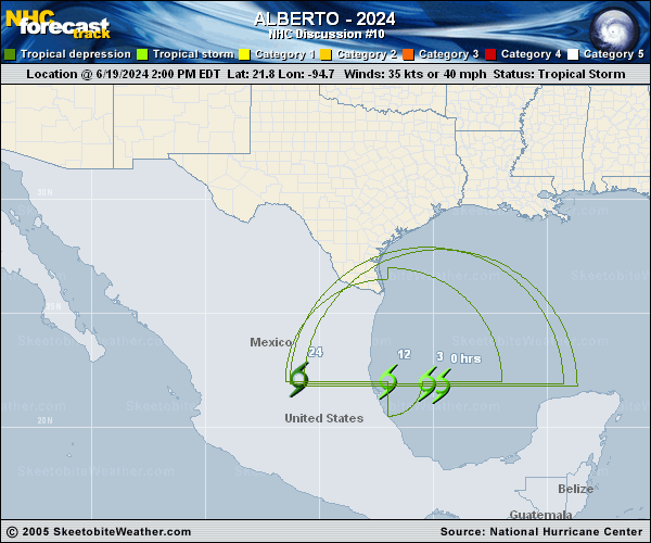
Copy of official data Tropical Storm Alberto Discussion Number 10 NWS National Hurricane Center Miami FL AL012024 1000 PM CDT Wed Jun 19 2024 Alberto is gradually becoming better organized this evening. Satellite and microwave imagery shows a band curving around the southern side of the center near areas of deep convection. An Air Force Reserve reconnaissance aircraft currently investigating the storm measured surface wind speeds of 43 kt and peak flight-level winds of 61 kt, with a much smaller radius-of-maximum winds than the previous mission. The intensity is set to 45 kt. The recent storm motion is generally westward at 8 kt. Model guidance insists Alberto will continue westward and accelerate as a ridge centered over the eastern United States builds over the area. The track guidance remains tightly clustered and predicts the center of the storm will reach the coast of Mexico overnight. Prior to moving inland, there is still a possibility that Alberto will slightly strengthen. The forecast now shows the storm dissipating over the mountains of Mexico in 24 hours. It is important to understand that Alberto is a large system and continues to produce heavy rains, moderate coastal flooding, and tropical-storm-force winds across portions of southern Texas and northeastern Mexico far from the storm center. It is also worth noting that the official wind speed probabilities are likely underestimating the chances of tropical-storm-force winds along the Texas coast because of the unusually large and asymmetric area of strong winds on the northern side of the circulation. Key Messages: 1. Users are reminded not to focus on the exact forecast track of this system. Alberto is very large with rainfall, coastal flooding, and wind impacts occuring far from the center along the coasts of Texas and northeastern Mexico. 2. Heavy rainfall associated with Tropical Storm Alberto will impact large regions of Central America, north across northeastern Mexico and into South Texas. This rainfall will likely produce considerable flash and urban flooding along with new and renewed river flooding. Life-threatening flooding and mudslides are likely in and near areas of higher terrain across the Mexican states of Coahuila, Nuevo Leon, and Tamaulipas, including the cities of Monterrey and Ciudad Victoria. 3. Moderate coastal flooding is likely along much of the Texas Coast through Thursday. 4. Tropical storm conditions are expected overnight along portions of the Texas coast south of San Luis Pass and along portions of the coast of northeastern Mexico within the Tropical Storm Warning area. FORECAST POSITIONS AND MAX WINDS INIT 20/0300Z 21.5N 95.9W 45 KT 50 MPH 12H 20/1200Z 21.7N 98.6W 35 KT 40 MPH...INLAND 24H 21/0000Z...DISSIPATED $$ Forecaster Bucci |